Thwaites Glacier in West Antarctica is currently the focus of a major scientific campaign. Why is Thwaites Glacier of so much interest, however? How much ice is there, and how much would sea levels rise if it all melted?
Thwaites Glacier is roughly the size of UK (176 x103 km2). The glacier terminus is nearly 120 km wide, and the bed of the glacier reaches to >1000 m below sea level. Pine Island Glacier and Thwaites Glacier together account for 3% of grounded ice-sheet area, but they receive 7% of Antarctica’s snowfall1.
Thwaites Glacier Mass Balance

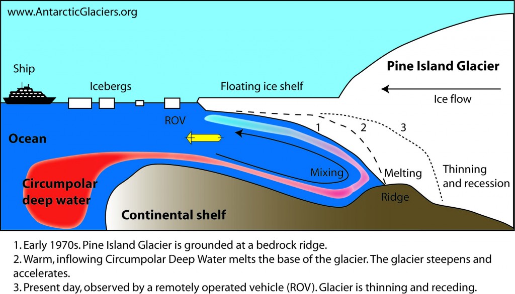
Incursions of warm water reaching the grounding line of the glacier are causing Thwaites Glacier to melt, which could cause rapid and irreversible sea level rise2. Currently, Thwaites Glacier contributes 0.1 mm per year to global sea level rise, which has doubled since the mid-1990s2. From the mid-1990s to 2010, ice loss from Thwaites Glacier increased to 52 Gigatonnes per year1.
Mass loss from Thwaites Glacier
Thwaites Glacier now has a greater mass loss than Pine Island Glacier or the Antarctic Peninsula. Altogether, the West Antarctic Ice Sheet lost 172 gigatonnes per year from 2012-20163.

Thwaites Glacier Marine Ice Sheet Instability
Why is Thwaites Glacier such a threat? And how much could it raise global sea levels? The key threat here is the potential for marine ice sheet instability. The wide glacier front (120 km) interacts with the ocean, making it vulnerable to melting from warm ocean currents.
As the bed of the glacier deepens after the grounding line, and the glacier thickens inland, it is a classic case of a potentially unstable marine ice sheet. As ice flux is dictated by ice thickness at the grounding line, retreat means that ice flux would inevitably increase – and this would provoke further recession into deeper water, greater ice flux and further contributions to sea level rise.

Thwaites Glacier Sea Level Equivalent
The volume of ice in Thwaites Glacier was recently re-examined by the BedMachine project4. This project, which includes analysis of radar data obtained from flying over the ice and a modelling approach to interpolate between flight lines, gives us the most detailed map of the glacier bed surface to date.

This new dataset tells us that Thwaites Glacier as a Sea Level Equivalent of 65 cm. It has a volume of 483 ± 6 x10³ km3 of ice, with a volume above flotation of 258 ± 6 x10³ km3 of ice. We can convert this into mm of sea level rise to give us the sea-level equivalent of 65 cm.
This value takes into account the volume above and below sea level (which already displaces water), and tells us how much global sea levels would rise if Thwaites Glacier were to melt completely.
Further Reading
Thwaites Glacier project website. There are some useful teaching resources on this page.
NASA Earth Observatory post on Thwaites Glacier
References
1. Feldmann, J., Levermann, A. & Mengel, M. Stabilizing the West Antarctic Ice Sheet by surface mass deposition. Sci. Adv. 5, eaaw4132 (2019).
2. Scambos, T. A. et al. How much, how fast?: A science review and outlook for research on the instability of Antarctica’s Thwaites Glacier in the 21st century. Glob. Planet. Change 153, 16–34 (2017).
3. Bamber, J. L., Westaway, R. M., Marzeion, B. & Wouters, B. The land ice contribution to sea level during the satellite era. Environ. Res. Lett. 13, 99502 (2018).
4. Morlighem, M. et al. Deep glacial troughs and stabilizing ridges unveiled beneath the margins of the Antarctic ice sheet. Nat. Geosci. (2019). doi:10.1038/s41561-019-0510-8

Just a thought: if you assume the entire glacier melts you may want to correct for the loss of volume below sea level due to the lower specific density of ice compared to sea water, approximately:
Increase = Vabove/Aocean*Rho(ice)/Rho(seawater) – Vbelow/Aocean*(1-Rho(ice)/Rho(seawater))
= 258000km3/391000000km2*0.9167/1.028 – (483000-258000)km3/391000000(1-0.9167/1.028) = 63.7cm – 6.7cm = 57.0cm
Still bad (and worse once the rise of the ocean floor due to decreased pressure is added).
Je m’étais fait la même réflexion et retenu 1/10 ème par simplification. Ma question est avez déjà tenu compte de la partie qui peut-être considérée comme étant équivalent a un iceberg flottant (même si encore rattachée) ?.
Can’t begin on the maths to support this, but what would a 57cm or 65cm rise in ocean levels do to land mass, and how much would this therefore decrease the overall rise?
It is time for quantum oceanography (Quantum Oceanography – 7).