Investigating Pine Island Glacier | Why is Pine Island Glacier important? | Pine Island Glacier ice shelf | Pine Island Glacier: the longer term view | Conclusions | References | Comments |
Investigating Pine Island Glacier
A fast-flowing ice stream
Pine Island Glacier is one of the largest ice streams in Antarctica. It flows, together with Thwaites Ice Stream, into the Amundsen Sea embayment in West Antarctica, and the two ice streams together drain ~5% of the Antarctic Ice Sheet1. Pine Island Glacier flows at rates of up to 4000 m per year2.
Pine Island Glacier is of interest to scientists because it is changing rapidly; it is thinning, accelerating and receding3, all of which contribute directly to sea level, and its future under a warming climate is uncertain.
Pine Island Glacier is buttressed by a large, floating ice shelf, which helps to stabilise the glacier, but this ice shelf is itself thinning and recently calved a huge iceberg.

Just watch how fast the ice flows in the video below, and notice especially how the ice speeds up when it reaches the floating ice shelf.
Caption: Visualisation of ice flow in the Antarctic ice sheet model PISM-PIK. The white dots show how particles move with the ice which are initially randomly distributed over the ice surface. Colours in addition show the flow speed. By Youtube user pikff1.
An inaccessible location
Despite this interest, Pine Island Glacier is difficult to access. It is remote from any research bases, so flying there means making multiple short flights, making fuel depots to allow scientists to hop to the location. Low lying cloud often makes flying hazardous. The ice stream is heavily-crevassed and dangerous, so walking on it is difficult. Sea ice keeps ships away, making it difficult to access the ice stream from the ocean.
However, scientists have several ingenious ways in which they can observe changes to this fragile, important ice stream. They can measure changes in ice extent and thinning from satellites4,5, and they have fired javelins loaded with sensors onto the ice surface, into places with too many crevasses for people to travel.
Finally, scientists on board ships have deployed ‘Autosub’ beneath the very ice shelf, to make observations where no man can go.

Exploring Pine Island Glacier
You can use Google Earth below to explore the ice stream. Can you identify the ice shelf? If you zoom in far enough, you’ll be able to see the huge crack in the ice shelf. You can also see how the surface of both the ice stream and ice shelf is heavily crevassed, making it difficult to walk on the surface of the ice.
View Pine Island Glacier in a larger map
Why is Pine Island Glacier important?
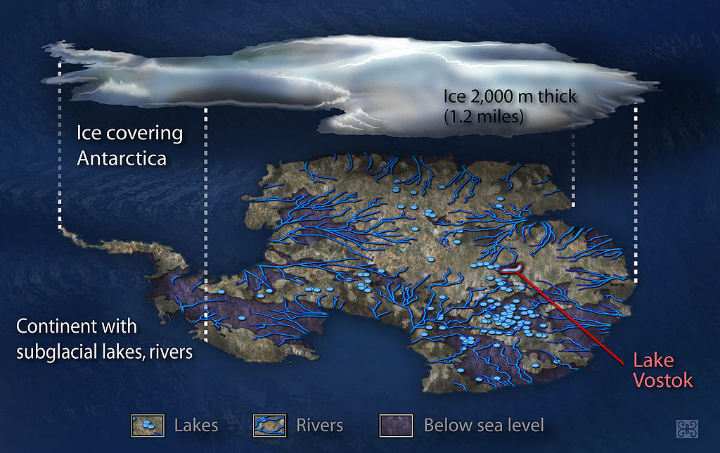
Pine Island Glacier drains much of the marine-based West Antarctic Ice Sheet, and it has a configuration susceptible to rapid disintegration and recession. The ice sheet in this area is grounded up to 2000 m below sea level, making it intrinsically unstable6 and susceptible to rapid melting at its base, and to rapid migration of the grounding line up the ice stream7 (see Marine Ice Sheet Instability).
The images below show how much of the West Antarctic Ice Sheet, especially around Pine Island Glacier, is grounded well below sea level.


Pine Island Glacier is one of the most dynamic features of the Antarctic Ice Sheet. It is buttressed by a large ice shelf that is currently thinning8, and the ice stream itself has a negative mass balance (the melting is not replaced by snowfall)3, it is flowing faster9, and the grounding line is retreating further and further up into the bay.

The grounding line receded by more than 20 km from 1996 to 20092. The ice stream is steepening, which increases the gravitational driving stress, helping it to flow faster, and there is no indication that the glacier is approaching a steady state10.
Possible future collapse?
Pine Island Glacier could collapse – stagnate and retreat far up into the bay, resulting in rapid sea level rise – within the next few centuries, raising global sea levels by 1.5 m11,12, out of a total of 3.3 m from the entire West Antarctic Ice Sheet13.
Some studies have suggested that the entire main trunk of Pine Island Glacier could unground and become afloat within 100 years14, but more recent modelling efforts suggest that much longer timescales are needed to unground the entire trunk2.
These numerical computer models indicate that annual rates of sea level rise from Pine Island Glacier could reach 2.7 cm per 100 years2. Under the A1B “Business as Usual” emissions scenario from the IPCC (2.6°C warming by 2100), Gladstone et al. (2012) predict recession over the next 200 years with huge uncertainty over the rate of retreat, and full collapse of the trunk of Pine Island Glacier during the 22nd Century remains a possibility15.

It remains difficult to assess how soon a collapse of Pine Island Glacier could occur, but a new paper by Bamber and Aspinall (2013) suggest that there is a growing view that the West Antarctic Ice Sheet could become unstable over the next 100 years16.
The largest contibution to global sea level rise from the Greenland and Antarctic ice sheets combined is around 16.9 mm per year, but is more likely to be around 5.4 mm per year by 2100. This gives a total of 33 to 132 cm of global total sea level rise by 2100. Uncertainty over the future behaviour of Pine Island Glacier in West Antarctica is one of the largest constraints on accurately predicting future sea level rise16.
Current behaviour
Pine Island Glacier is currently flowing very quickly and it is accelerating, causing thinning. The velocity is well above that required to maintain mass balance – so the ice stretches longitudinally, and thins vertically3.
In the figure below, from Rignot et al. 2008, you can see that mass losses from Pine Island Glacier and Thwaites Glacier dominate Antarctic Ice Sheet ice losses. Mass loss from this basin doubled from 1996 to 2006, and it is the largest ice loss in Antarctica.
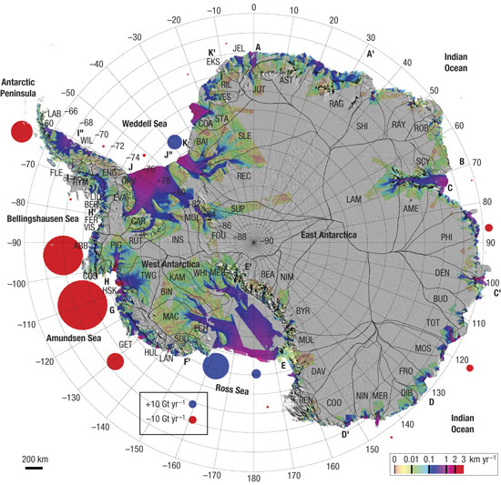
(Rignot et al., 2008), copyright 2008
Pine Island Glacier ice shelf
Pine Island Glacier has a large ice shelf, which supports the glacier. Removal of the ice shelf would likely result in rapid acceleration, thinning and recession as the glacier adjusts to new boundary conditions; these reactions have been observed following ice shelf collapse around the Antarctic Peninsula17-21.
The ice shelf around Pine Island Glacier is currently thinning, and it is warmed from below by Circumpolar Deep Water that flows onto the continental shelf22,23. This melts the ice shelf from below24, and this melting is probably the cause of the observed ice stream thinning, acceleration and grounding line recession25, which is contributing to a sea level rise of 1.2 mm per decade3.
Calving Icebergs
Pine Island Glacier ice shelf periodically calves huge icebergs. The ice shelf currently loses around 62.3 ± 5 Gigatonnes per year of ice through calving, and loses 101.2 ± 8 Gigatonnes per year through basal melting24. It calved a large iceberg in 2001, and in 2011 a huge rift developed on the ice shelf. This iceberg was finally calved in July 2013. It’s about eight times the size of New York, or half the size of Greater London, at 720 km2.
However, this iceberg calving event is a natural process, part of how the ice shelf regularly calves – this ice shelf spawns huge icebergs every 6-10 years. Releasing a huge iceberg, by itself, is a normal process, unrelated to warming, but increased calving may occur in the future if the ice shelf continues to thin, which would make it susceptible to plate bending and hydrofracture processes21. This threshold has yet to be passed.

Current melting, thinning and acceleration
What is concerning is the current intense melting, thinning and glacier acceleration observed on Pine Island Glacier ice shelf22. Measurements from the British Antarctic Survey’s Autosub, the intrepid sub-ice shelf explorer, help scientists understand sub-ice conditions.
Autosub is a remotely operated vehicle, loaded with sensors that measure temperature, salinity, pressure and so on, and it can map the sea bed using downward-pointing swath bathymetry. It can dive to 1600 m and travel 400 km, and it has a clever collision avoidance system. It’s a dangerous business; several iterations of Autosub have been lost under the ice.
However, data from Autosubs that did return indicates that more warm Circumpolar Deep Water has been in Pine Island Bay in recent summers22. Meltwater production underneath the ice shelf increased by 50% from 1994 to 2011; this increased melting results from stronger sub-ice-shelf circulation. As the ice shelf thins, more water is able to circulate beneath it22, exacerbating the problem and encouraging further melting.

Pine Island Glacier ice shelf now has one of the fastest rates of ice-shelf thinning in Antarctica24,25.

(Pritchard et al. 2012), copyright (2012).
Pine Island Glacier: the longer term view
It is important that we take a longer-term perspective of the current changes observed on Pine Island Glacier. Are these on-going changes unprecedented, or are they part of the normal behaviour for the glacier? Marine sediment cores and swath bathymetry from ships can image the sea floor and detect and date the former behaviour of this ice stream.
These data suggest that the recession of this ice stream was largely controlled by sea level rise, with a 55 m in sea level rise during deglaciation resulting in 225 km of grounding-line recession26.
At the Last Glacial Maximum, circa 18,000 years ago, the ice stream was at the continental shelf edge27. It rapidly shrank back from around 16,400 years ago, when rising sea levels made this ice stream more buoyant, causing lift-off, decoupling from the ice sheet’s bed, and recession.
The ice stream continued to recede from 16,400 to 12,300 years ago, controlled by global sea level rise. It reached its current position around 10,000 years ago27.
The recession of the ice stream was also controlled by the presence or absence of ice shelves. From 12300 to 10600 years ago, there was a large ice shelf throughout the Amundsen Sea Embayment. This ice shelf collapsed after 10600 years ago28, when warmer waters flowed onto the continental shelf. The grounding line of the ice stream retreated rapidly following ice-shelf collapse26.
It seems that the glacier is capable of very rapid recession within millennial timescales27, and that the dynamics between ice shelf and ice stream are intrinsically linked. More work at a higher resolution, combined with modelling studies, is required to fine-tune and better understand the longer-term history of Pine Island Glacier.
Conclusions
Pine Island Glacier is a cause for concern, because it’s thinning rapidly, steepening, accelerating and receding. It is out of balance. Huge amounts of meltwater are generated in a large cavity beneath the ice shelf. It periodically, every 10 or so years, calves large icebergs – but on their own, they are not worrisome. The recently calved iceberg may be 720 km2, but that’s the least of this ice stream’s worries. This ice stream is unlikely to collapse in our lifetime – but the same cannot be said for future generations.
Pine Island Glacier is one of the largest ice streams in Antarctica, and drains much of the West Antarctic Ice Sheet. Because it is grounded in ever deeper sea water, it is vulnerable to melting at its base and rapid grounding line migration. A collapse of Pine Island Glacier could occur within 1000-2000 years, raising sea levels by up to 1.5 m, but it is unlikely to contribute to more than 2.7 cm of sea level rise over the next 100 years.
Wider Reading
- Marine Ice Sheet Instability
- Ice Shelf Collapse
- Ice-Ocean interactions
- Antarctic Peninsula Ice Shelves
- West Antarctic Ice Sheet
- Future sea level rise from ice sheets
- Antarctica’s contribution to global sea level rise
Go to top or jump to Marine Ice Sheet Instability.
If you examine the MODIS imagery are you sure about the July 2013 calving date, no separation occurred until November 2013? http://glacierchange.wordpress.com/2013/11/13/pine-island-glacier-2013-iceberg-rift-update/
The first reference to this being the weak underbelly is Hughes (1981).
Hughes T. (1981). “The weak underbelly of the West Antarctic Ice Sheet”. Journal of Glaciology 27: 518-525.
Note article at Realclimate.
http://www.realclimate.org/index.php/archives/2009/11/is-pine-island-glacier-the-weak-underbelly-of-the-west-antarctic-ice-sheet/
Is it possible to artificially freeze the melting glaciers with solar powered freezing mechanism to stop the melting ice?
Even though the text under the picture says ‘Simplified cartoon of a tributary glacier feeding into an ice shelf’, it is misleading. Do we want that?
It suggests:
1. that the ice has roughly a third of the density of water (under/over water ratio of the floating blocks).
2. hence that the ice is breaking of because of water pressure from below.
If the ice isn’t in fact that surprisingly low density, I would suggest you correct that.
This deep grounding makes the ice sheet inherently unstable and prone to rapid melting at its base. Additionally, the grounding line, which marks the boundary between the grounded ice and the floating ice shelf, is susceptible to rapid migration up the ice stream.
awesome