This section was contributed by Prof. John Smellie.
Introduction | Subglacial volcanoes as an ice sheet proxy | Glaciovolcanism in Antarctica | The Pliocene Antarctic Peninsula Ice Sheet | Late Miocene East Antarctic Ice Sheet | Antarctic refugia | References | Comments |
Introduction

In common with other environments, volcanoes also erupt beneath ice sheets and glaciers. Examples are well known from currently and formerly glaciated regions of the world, particularly Iceland, British Columbia and Antarctica. Subglacial volcanoes are distinctive and have been given their own title: “glaciovolcanism”. Glaciovolcanism is defined as “the interactions of magma with ice in all its forms, including snow, firn and any meltwater” [1,2]. It is a very young science with a history of sporadic research extending back less than a century but interest in the topic has expanded dramatically since about 2000. As well as providing invaluable information on the construction of volcanoes in a uniquely hostile and inaccessible environment, important when predicting the consequences of modern glaciovolcanic eruptions (e.g. Eyjafjallajokull in Iceland, 2010), studies on subglacial volcanoes have also been developed into what is probably now the most powerful methodology for deriving multiple critical parameters of past ice sheets, mainly the Antarctic Ice Sheet [e.g. 3,4,5].
Subglacial volcanoes as an ice sheet proxy
Studies of past ice sheets using glaciovolcanic outcrops are still in their infancy. They are best developed for examples in Antarctica, where the two largest investigations have now been completed. Because ice is not preserved in the geological record (it melts), it is not intuitively obvious how subglacial volcano sequences can preserve a detailed record of that ice. However, the following information can be derived routinely from glaciovolcanic sequences [1,3,4]:
- Was ice formerly present?
- Ice thickness.
- Ice basal thermal regime (see Glacial Processes).
- Ice surface elevation.
- Ice sheet structure.
These questions are important because answering them will help us understand past ice-sheet responses to environmental change – and this will help us to predict future change better. See: Why study Antarctic glaciers?
Because the volcanic sequences are typically quite thick (hundreds of metres) and contain resistant rocks such as lavas, they are able to persist through multiple overriding events by ice, unlike many much thinner (typically just metres) glacial sediments. However, volcanic eruptions commonly occur at intervals of several tens to hundreds of thousands of years. Thus, the volcanic record is coarse in resolution, comparable with terrestrial glacial sediments but generally worse than in marine sediments.
Glaciovolcanism in Antarctica
Antarctica is the largest glaciovolcanic province in the world. There are many volcanoes and they occur all the way from the sub-Antarctic South Sandwich Islands, through the Antarctic Peninsula and Marie Byrd Land, and into East Antarctica, a distance of about 5000 km. Eruptions coincided with the development of the Antarctic Ice Sheet. The volcanoes are overwhelmingly basaltic and there are few examples of more evolved magmatic compositions [6,7]. They range from very large stratovolcanoes with summit elevations up to 4000 m above sea level and basal diameters of 40 to 60 km, to volcanic fields composed multiple small centres [6,9]. The individual volcanoes are often extremely beautiful but the extensive cover of snow and ice and the remote locations can make accessing them quite challenging.
Unlike lower-latitude volcanoes which are typically obscured extensively by vegetation, volcanic outcrops in Antarctica are characteristically very clean and beautifully exposed. In places such as northern Victoria Land, cliff sections up to 2 km high extend 10 or 20 km laterally [8]. However, many volcanoes have minimal exposure or have been extensively removed by multiple overriding ice sheets, particularly in the Antarctic Peninsula. A curiosity of subglacially erupted volcanoes is that, because they are formed of alternating thick sections of lavas and fragmental rocks and are therefore technically stratovolcanoes, the frequent development of lava-fed deltas (see below) has resulted in volcano profiles with slopes less than 15° that are normally associated with (lava-dominated) shield volcanoes. Both terms have been used to describe Antarctic volcanoes.
The Pliocene Antarctic Peninsula Ice Sheet

This section should be read in conjunction with Antarctic Peninsula Ice Sheet Evolution.
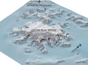
The Antarctic Peninsula hosts numerous mainly small volcanic edifices with ages extending between 7.5 million years ago (Ma) and present [6,9]. Conversely, several much larger stratovolcanoes are present in the northern part of the region [10,11]. Of the latter, the longest-lived and most important by far is the James Ross Island Volcanic Group (JRIVG) which is dominated by the Mt Haddington volcano. In situ outcrops in the JRIVG extend back to 6.25 Ma but eruptions probably commenced at least 10 million years ago. Several of the volcanic outcrops in the Antarctic Peninsula were important for defining features of subglacial volcanoes and glaciovolcanism that resulted in fundamental advances for understanding volcano construction as well as for palaeoenvironmental investigations [e.g. 12-15]. The morphology and other important characteristics of the Antarctic Peninsula Ice Sheet are extremely poorly known for periods prior to the LGM.
Two generic types of glaciovolcanic sequences are present in the Peninsula, known as sheet-like sequences (a sequence type defined in Antarctica; 12,16] and sequences dominated by multiple lava-fed deltas (a lava-fed delta is analogous to a sedimentary delta but formed entirely by volcanic rocks, i.e. subaerial capping lavas (“topsets”) overlying subaqueous foreset hyaloclastite breccias (2,15). Characteristics of the sequences enabled a detailed history of ice sheet thicknesses to be deduced, which showed that the Antarctic Peninsula Ice Sheet has varied in thickness up to c. 850 m but was typically much less (< 400 m) for the period 6.25 million years ago to present [3,4]. It thus simply draped rather than drowned the landscape although it was probably persistent even through ice-poor periods corresponding to interglacials [17]. The basal thermal regime was overwhelmingly polythermal (sub-polar) [2,18,19].
Late Miocene East Antarctic Ice Sheet

Glaciovolcanic sequences deposited by subglacial volcanoes are also widespread in northern Victoria Land, mainly as overlapping very large stratovolcanoes or volcanic shields. They are scattered along c. 400 km of the periphery of the present East Antarctic Ice Sheet that faces the Ross Sea [8]. The sequences are mainly Late Miocene in age (c. 12-5 Ma) and consist of several main types: lava-fed deltas, volcanic sheet-like sequences, a glacial-lacustrine sequence and pyroclastic cones [7]. They were formed in association with a glacial cover that was typically only a few hundred metres thick (< 300 m). There is also no evidence ice-free conditions, which therefore either did not occur or else left no record.
These observations suggest the presence of a thin persistent Late Miocene ice dome or icefield draping the pre-Miocene topography in northern Victoria Land for the period, although it may have been confluent with the greater East Antarctic Ice Sheet similar to conditions present today [5]. The Late Miocene was much warmer than today but the Transantarctic Mountains hinterland was already uplifted to its current elevation prior to the volcanism and helped the ice sheet to establish and persist. The glacial thermal regime varied from wet-based and dynamic, to cold-based (frozen to its bed) and presumably relatively stable. The glacial thermal regime was dominantly polar since the earliest eruptions but with several temporary changes to a wet-based (sub-polar or temperate) more dynamic regime.
Antarctic refugia

An important spin-off of the studies on subglacial volcanoes in northern Victoria Land and the Antarctic Peninsula is the recognition that ice sheets persisting for millions of years were typically thin and were not the much thicker ice sheets most modelling studies had suggested. The new results thus provide for potential ice-free surfaces as refugia for plants and animals that evolutionary and biogeographical studies of contemporary Antarctic terrestrial and marine biotas are now suggesting had ancient origins and persisted through multiple glacial cycles extending back in time millions of years [20].
Further reading
Go to top or jump to The Sirius Debate.


Pingback: What Causes Volcanoes?
” The Late Miocene was much warmer than today”
Global Warming?
Different continental position and different atmospheric and oceanic circulation patterns.
Illustrations shown are just that- ‘illustrations’.
‘Cartoons’ imply humor – they are definitely Not ‘cartoons’
Actually, a cartoon does not necessarily imply humour unless, of course, you find those drawn by Leonardo da Vinci funny. A cartoon is actually an unrealistic, or exaggerated visual representation of a particular subject, which I presume is not what the author intended. I’m afraid your pedantry has been met by further pedantry in order to support what I consider a highly informative article, with the exception of its one trivial semantic blemish that has so engaged you.
August 2017. https://www.geos.ed.ac.uk/homes/rbingha2/48_2017_Vries.pdf
Antarctic ice melt will very soon be a self perpetuating volcanic reaction
The plates are relatively “soft” at the poles.
As trillions of tons of weight from ice melt comes off the glaciers grounding points, the soft plates will continue moving more and more radically creating new volcanic fissures at grounding points.
This in turn creates more disturbance and heat which accelerates the melting and the cycle continues until the cycle levels out.
Long after seas have risen and done their damage
Pingback: Hundreds Of Volcanoes Lurk Beneath Antarctica’s Ice Sheet: Are They Melting The Polar Ice From Beneath?