In temperate parts of the world, glaciers are wet and watery environments. The front of a glacier is characterised by water melting from the top and from underneath the ice, and by sediment sloughing off. In places where these glaciers terminate on land, instead of into a lake or the ocean, such as Svalbard, Patagonia, Alaska, the glacier forefield is dominated by glaciofluvial landforms and sediments. These can be very extensive, forming an important part of the glacial landsystem.
Glaciers here in Svalbard have a mixture of temperate (ice is melting at the bed) and cold-based (frozen to the bed) ice, which means there is some variability in the glaciofluvial landforms in front of the glaciers, as we’ll see below.

During the ablation season, meltwater runs off the glacier and runs downslope, into local rivers. The meltwater is cold and laden with suspended sediment, giving it a milky or brown colour. Subglacial meltwater can exit from the glacier under quite a lot of force, leading to an impressive sight! The meltwater’s sediment is then deposited on the glacier forefield, leading to the deposition of a suite of characteristic landforms.
Here we will focus on characteristic fluvioglacial landforms from land-terminating glaciers from Svalbard. The key glaciers discussed are shown on the map.

Supraglacial channels
In the ablation area of glaciers, meltwater channels will form on the ice surface. They can form beautiful wiggly patterns as the water incises down into the ice. Sometimes the water will reach a crevasse or weakness in the ice, whereupon it will make its way to the bed. Here at Antoniabreen, you can see some well developed supraglacial meltwater channels on the ice surface, which flow down the glacier into a proglacial meltwater channel.
Supraglacial meltwater usually does not have much sediment within it, so is usually clearer than subglacial meltwater. At Antoniabreen, you can see that the ice surface at the snout is a dull grey colour from windblown-dust accumulating on the ice surface, and there may be some rocks and other debris on the ice surface that can be washed into streams. However the sediment load is usually far less than the subglacial meltwater channels where there is active erosion underneath the glacier.

Proglacial lakes
At Penckbreen, as at many other glaciers, the glacier ends not on land, but in a proglacial lake. You can see the terminus of the glacier on the left, and lots of little icebergs within the lake. The water is milky in colour because of all the suspended sediment within the glacial meltwater. This tells us that much of the meltwater has come from the bed of the glacier; meltwater from the ice surface is mostly melted snow and ice, and is much clearer.
The meltwater from the bed of the glacier has fine-grained sediment suspended within it, from the action of the glacier eroding the bedrock beneath it.

Subglacial Conduits
Glacier ice melts under pressure, and because of geothermal heating. This means that the bed of a ‘temperate’ glacier is a very wet, watery place, with water collecting and flowing in subglacial rivers. These rivers flow under high pressure and essentially follow the pressure gradient exerted by the weight of the ice above. This means that the water will flow towards the glacier terminus, where the ice is thinner.
The subglcaial water of temperate glacier ice is laden with fine-grained suspended sediment produced by the action of the glacier grinding and polishing the rocks up-ice. Cobbles and pebbles are also carried along by the high-pressure water, and may become quite rounded in this environment, looking rather different to rocks carried either on the ice surface (angular and sharp-edged) or eroded underneath the ice (sub-rounded, often with polished faces and scratches).
If the glacier is frozen to the bed, there is no subglacial melting. For these cold-based glaciers, meltwater flowing at the margins cannot penetrate underneath the ice. Most glaciers in Svalbard have a mixture of cold-based and temperate ice, and so have a polythermal regime.
At Charlesbreen, below, a river is flowing underneath the glacier. Above the water, you can can see the glacier ice, and left and right of the river, you can see the glacial sediments that the river has cut down into. These are diamictons, or unsorted clays with sand, gravels and boulders within it, which are typical of subglacial sediments.

In the video below, we are standing in a dry, abandoned subglacial channel at Charlesbreen. The glacial meltwater now exits just along the ice margin. You can see how smooth and sculpted the ice walls are, polished by the meltwater.
In the picture below, glacial meltwater is flowing under the glacier, forming a subglacial meltwater channel. Here at the terminus, it exits the glacier.

Eskers
The sediment-laden rivers flowing underneath glaciers may slow down, or stop flowing. This may be because the water flow is diverted to another channel, or because the water dries up in winter. If the flow stops, the sediment is rapidly deposited within the subglacial channel. The shape of the resulting landform, an esker, resembles the shape of the subglacial channel, and the slumping of material after deposition.
There is a substantial esker at Bakaninbreen, in Svalbard. After the glacier retreated, the esker was left behind, standing proud in the landscape, above the outwash plain. The esker has a sharp crest and a zig-zag shape, and is formed from the sediments that were being transported as bedload within the subglacial river.

Meltwater channels
Fast-flowing and sediment-laden glacial meltwater is very erosive. It easily incises (cuts down) into glacial sediments plastered across the foreland. The meltwater may track around the margin of the glacier, especially if the glacier is cold at its snout and so the water cannot reach underneath the glacier. This is common in places with polythermal glaciers, that are temperate higher up-ice (where the ice is thicker), and cold-based and frozen to the bedrock at the snout, where the ice is thinner.
At Antoniabreen, Svalbard, the marginal meltwater channels have incised downwards through the sediments. A series of nested channels is formed as the glacier retreats. There are no moraines here, because the glacier is retreating and is not forming moraines. The glacier is cold at its snout, so the water cannot penetrate again under the ice. The meltwater channels therefore form across the slope, tracking the glacier snout’s position.

Outwash Plains
Once the water flows away from the glacier, it usually forms a braided network of proglacial meltwater channels. The low-slope foreland of the glacier is often dominated by these sandur, or outwash plains.
At Charlesbreen, the outwash plain has a lot of sediment deposition, because of the high sediment load in subglacial meltwater. The sediment is deposited, and then reworked, on the outwash plain. Often, this outwash plan removes and washes away any other glacial landforms. Here, you can just see a few remenants of sharp-crested moraines on the left, marking out the position of the former ice margin.

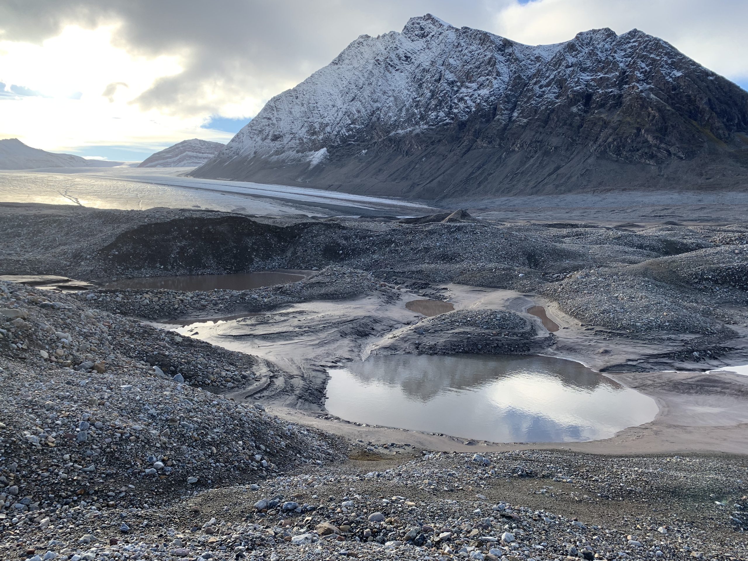
Kames and Kettles
Kettle lakes form when blocks of ice are left behind in the landscape as glacier ice retreats. This is common, because as glaciers recede and thin, the snout often becomes chaotic, with jumbled up, broken blocks of ice, which can become debris-covered. The ice can also be buried by glaciofluvial sediment.

As the ice melts, the space formerly occupied by the ice forms a small, usually rounded, pond.

Kames are a mound, or group of mounds, of poorly sorted sands and gravels, deposited from the running water around glacier ice.
Kames can also form between the glacier and the hillside, where water can be trapped. Here, the resulting landform may be a terrace running along the valley side, called a kame terrace.
Because kettles and kames are related, they form a typical landscape called a kame and kettle topography. This can be seen at Charlesbreen, below.
Further reading
Wider literature
Delaney, C., 2002. Sedimentology of a glaciofluvial landsystem, Lough Ree area, Central Ireland: implications for ice margin characteristics during Devensian deglaciation. Sedimentary Geology 149, 111-126.
Marren, P.M., 2002. Fluvial–lacustrine interaction on Skeiðarársandur, Iceland: implications for sandur evolution. Sedimentary Geology 149, 43-58.