Glacial troughs and fjords are deep erosional features calved into bedrock marking glacial activity [1,2]. The most characteristic difference between a trough and a fjord, is that a fjord ends in a coastal region, and is flooded by sea water [3]. These landforms can be located in a series of geographical locations and are characterised differently dependent on their climate regime. These include polar, sub polar, and temperate.
Polar fjord types such as the Lallemand Fjord in on the Antarctic Peninsula, or fjords found in Greenland and the Canadian Arctic are almost always covered by sea ice, or contain ice shelves and glaciers. Subpolar fjords occur in regions where summer temperatures reach above freezing and thus have seasonal sea ice cover. And finally, temperate fjords, such as the Nærøyfjord in Norway and the Doubtful Sound in New Zealand, do not have sea ice present. These fjords typically are non-glaciated today, and only present due to past glacial advances [4].
Troughs and Fjord Formation
The formation of such landforms occur over long geological timescales, from 10,000 years to over 100,000 years, and across multiple different glaciations [3]. Troughs are also referred to as U-Shaped Valleys due to their parabolic shape with very steep sides, and flat bases [3]. Their formation occurs through a combination of erosional processes including fluvial activity, weathering, and both glacial, and periglacial activity [1,3].
Glaciers which advance through topographically confined valleys pluck large boulders and sediment from the bedrock and lower sidewalls [3,5]. The boulders become entrained within the ice, and are transported at the base of the glacier, resulting in abrasion. Over time, this process of glacial erosion, in combination with periglacial activity, forms a glacial trough with a characteristic parabolic shape [1,3]. These erosional processes are strongly dependent on the bedrock geology and the ice thickness, therefore vary in different geographical regions [1,5].

Glacial trough in Greenland. 
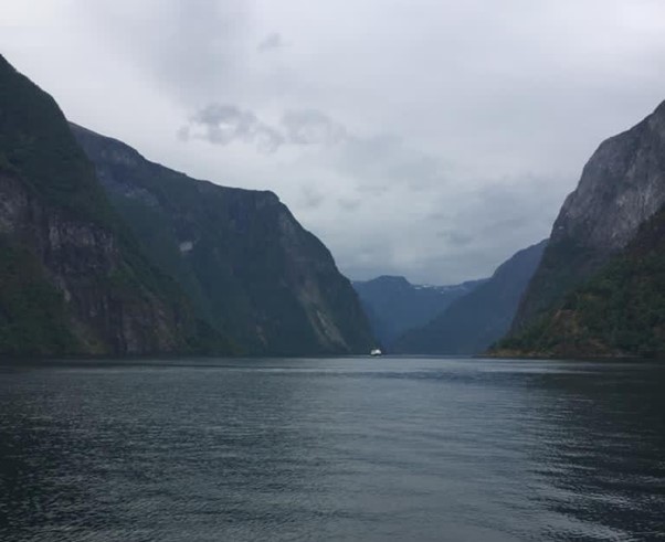
Fjords
At the previous terminal position of the glacier, where erosion is lower, and sediment can be deposited, a formation known as a glacial sill, submarine ridge or morainal shoal may form. This forms a barrier between the mouth of a fjord and the fjord valley.
As sea levels rise over time due to tectonic activity and glacial melt, the valley begins to flood and is submerged with sea water. The sill at the mouth causes an over-deepening with seaward water levels being considerably lower than the fjord water depth [6]. Sognefjord in Norway is one of the deepest fjords in the world, with a maximum depth of over 1000m. Because of their expansive depths, fjords often make great spots for large tourist ships to sail down and explore past glacial landscapes.
The presence of sills at the mouth of the fjord can also have implications for the basin water [7]. Because the fjord basins are semi-enclosed, it allows the water to become stratified during certain seasons with little to no mixing through the water column. This leads to cool temperatures and little oxygen at the base. Because of the change in hydrology, scientists can use fjords as “mini ocean laboratories” to study different hydrological, biological, and sedimentological processes which are much more accessible than oceans.
Markers of Past Environments
Not only do troughs and fjords act as evidence for past glaciation, they can also contain clues about past glacial processes, and responses to change [8]. Examples of this includes scour marks or striations on the trough floor due to the entrainment and transport of plucked material at the base of a glacier [3,5]. Mega scale glacial lineations (MSGL) on the fjord floor demonstrates that the retreat of the past glacier and ice sheets occurred relatively fast [8].
These past markers of change are important for glaciologists today to understand about rates of ice change, changes of sea level, and they can even tell us about past geological hazards.