A glacier model is a simple way of describing a glacier or ice sheet, using well-understood mathematical relationships, such as the deformation rate, amount of melting, snowfall and precipitation.
There are quite a few interactive glacier models on the internet that you can play with. Use these models to experiment with making glaciers and ice sheets shrink and grow by changing temperature, precipitation, slope and other variables.
These glacier models might be fun for someone studying for a Geography A-Level or a Year 1 or 2 undergraduate to play with.
PHeT
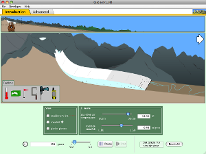
PHeT from the University of Colorado at Boulder has an excellent interactive glacier simulation that you can use to change precipitation and temperature to grow or shrink a glacier. Use the tools in the bottom left hand corner to measure glacier thickness, velocity, distance from headwall, and things like accumulation and snowmelt. You can also click to see the real glacier that the model is based on.
| Click to Run |
Download the file and save it to your desktop, or run the model in your browser. This model has a simple interface for new learners and a more advanced interface for more experienced learners.
Can you identify the snowline and equilibrium line altitude on the glacier? Using the advanced option, what can you tell about debris that is caught in the ice? What does this tell you about the formation of moraines? Can you see crevasses in the glacier ice? Note how the glacier ice keeps moving forward, even when the glacier is receding.
This page has some suggestions for projects for A-Level and Undergraduate Geography students, using this model.
University of Kentucky
This very simple glacier model from the University of Kentucky allows you to change snowfall and temperature to make a cirque glacier grow and shrink. This model shows a plan-view map of a simple mountain glacier, and it’s good for exploring concepts such as glacier flow, accumulation and ablation.
What combinations of snowfall and temperature make the glacier biggest? What happens if temperature is high but snowfall is also high? This model is very easy to understand, and great for younger learners.
OGGM-edu
 The Glacier Simulator produced by the OGGM-edu team runs on the Open Global Glacier Model, and provides an excellent introduction to numerical modelling. This is probably more suited to undergraduate or graduate level rather than A-Level students.
The OGGM Glacier Simulator has a Beginner and an Advanced mode, allowing students to become more familar with the basic concepts before moving onto something more challenging. It runs in the browser and does not require any programs to be downloaded or installed. I found it very intuitive to use.

GNS
GNS has an interactive glacier model and you can change slope, snow, temperature, and various other parameters to make the glacier flow and get bigger or smaller. Download the icon to your desktop and run it. Move the sliding bars up and down to watch the glacier grow and shrink. This is a 1D flowline model simulation.
JISM
JISM (JavaScript Ice Sheet Model) is an interactive ice sheet model of the Greenland (G) and Antarctic (A) ice sheets. You can vary the temperature using the slider (in Kelvin) in one degree increments, and watch the ice sheets shrink or grow. Ice sheets take up water when they grow and release water to the oceans when they shrink; turn on “Sea Level Lowering” to watch sea levels go up and down. This model is more difficult to understand but great for undergraduate students.
JISM is based on Frank Pattyn’s GRANTISM model, and was made by Martin O’Leary from Swansea University. See the GRANTISM website for more information.
Portland State University
This Virtual Glacier from Portland State University allows you to experiment with changing a number of variables to make a glacier advance and retreat. Click on the Small or Large viewing size to bring up the model, and work through the different Modules to change different aspects of the glacier. Under each Module, you’ll need to click on ‘Model’ on the left hand sidebar to bring up the glacier model. This is a simple 1D flowline model.
I like the Kentucky model for student use. In particular you can specify each student compare two specific climate unique inputs so that none are a replicate. Then have them apply this to a specific unique glacier. I typically use the Swiss glacier retreat list which has enough glaciers with annual retreat records at your fingertips so each of my 60 students uses a different glacier. http://glaciology.ethz.ch/messnetz/glacierlist.html
Thanks for this comment and the link! That’s a huge, comprehensive and very useful database of glacier lengths. Sounds like an interesting idea for a student practical.
Another very simple interactive model you might include is this one, produced as part of the IPY (and translated into a few different languages by APECS) which lets you change temp/precip as well as surging, etc.: http://intern.forskning.no/arnfinn/polaraaret/glacier.html