By Lauren Rawlins, University of York
Since the early 1990’s, the amount of meltwater on the Greenland Ice Sheet has dramatically increased due to rising air temperatures from climatic warming and darkening of the ice surface (1). Observations from satellite imagery over this time have seen the supraglacial hydrology system become more extensive, form further inland and be active for longer (2-3).
As this meltwater will ultimately end up in the ocean, whether that is by direct evacuation off the ice edge or the eventual channelisation of melt from the en- or sub-glacial systems, it directly contributes to sea level rise.
Understanding what the supraglacial hydrology system looks like and how it behaves is very important for estimating how much melt the Greenland Ice Sheet is losing from its surface and how quickly is it therefore contributes to sea level rise.
This is particularly important with the inland expansion of these systems expected under continued climatic warming (2-4).
What is supraglacial hydrology?
Supraglacial (ice-surface) hydrology refers to the study of water flow on the surface of glaciers, ice sheets and ice shelves during the summer season when temperatures are above freezing (0°C) and meltwater is readily available for runoff.
Supraglacial melting
We all know that ice will melt if temperatures rise above 0°C. For many glaciers, this melting is the main way in which they lose mass. In Greenland, there is surface melt across wide areas of the ice sheet.
This happens mostly in the ablation zone, where there is net melt over the course of the year.
Ice is impermeable, so any meltwater on the ice surface can’t be absorbed back into the ice. Instead it stays there, and forms ponds or channels. These channels will direct water downslope, towards the ice margin. If it intercepts a crevasse, the water might drain downwards towards the bottom of the ice sheet.
In Greenland, there is therefore a supraglacial (ice-surface; ‘supra’ means ‘on top of’), subglacial (beneath) and englacial (within) hydrological system.
A complex system
This system can be very complex, made up of various components (Figure 1a), including supraglacial channels that transport meltwater long distances across the ice surface (Figure 1b), the storage and/or drainage of meltwater via supraglacial lakes (Figure 1c) and the interception of these features by moulins and crevasses (Figure 1d) that provide direct connections from the ice surface to the en- and sub-glacial hydrology systems.
Even though supraglacial hydrology is known to play a key role in meltwater transport on icy surfaces, it remains “one of the least studied hydrologic systems on Earth” (5) and the distribution of supraglacial channels across glaciated regions, particularly on the surface of ice sheets, remain largely unmapped (6).

What are supraglacial channels?
Supraglacial channels are river-like features incised into an ice surface that transport large volumes of meltwater across glaciers and ice sheets during the summer months (Figure 1).
These channels can vary in size and shape, ranging from a few centimetres to several metres wide and can reach up to tens of kilometres in length. Together, a whole suite of these differently sized channels makes up the supraglacial hydrologic system, with networks of smaller tributary-like streams feeding into larger rivers, which typically reappear in the same locations every year despite ice movement(5,7).
Video 1 This video from researchers at UCLA shows an example of a flowing supraglacial river channel on the Greenland Ice Sheet. These turquoise rivers transport large volumes of meltwater during the summer melt season at high speeds.
Supraglacial channels look very similar to the rivers and watercourses we find in terrestrial systems. They have features such as meanders, meander cut-offs similar to oxbow lakes, braiding characteristics and knickpoints (figure 2) (8-10).
However, a key difference is the process of how supraglacial channels form and evolve. Unlike bedrock and alluvial systems, supraglacial channels have little-to-no sediment load (e.g. rocks) and form and evolve through a process called thermal erosion(11), which is simply heat generated from the friction of moving meltwater. Thermal erosion can lead to downcutting (or ‘incision’) into the ice of ~10 cm a day(12), which is more rapid than the surrounding melting ice. This means supraglacial channels can develop and evolve very quickly, and faster than those in ice-free areas.

Supraglacial hydrology on the Greenland Ice Sheet
Glaciologists have been closely studying supraglacial channels on the Greenland Ice Sheet, especially within the satellite era (from the 1970’s) where images from space reveal their spatial patterns and dynamics. The recent availability of higher resolution satellite datasets (e.g., Sentinel-2) have also improved these mapping and modelling studies, allowing channels to be observed and characterised at much greater detail (5, 13-15), particularly around Greenland’s fast-flowing western margins.
The longest supraglacial channel on the Greenland Ice Sheet to-date is located in the northeast at Nioghalvfjerdsbræ , also known as 79°N Glacier. This single, very windy channel is ~81km long and stretches down the ice shelf ending at its edge.
In the Sentinel Playground image below, you can see supraglacial channels on the Greenland Ice Sheet. Click the image below to be taken to Sentinel Playground and explore the imagery.

There is some debate as to whether supraglacial channels play a positive or negative role in ice shelf stability/instability. On one hand, channels could influence the disintegration of ice shelves due to the ‘loading’ of meltwater, which can put pressure on the ice shelf causing them to fracture (16-18).
Alternatively, channels could help ‘buffer’ their collapse by quickly transporting meltwater off ice shelves helping to reduce water-induced stresses and prevent their breakup (19). Either way, understanding of their role is critically important for both the Greenland and Antarctic ice sheets.
What are supraglacial lakes?
Supraglacial lakes are areas of ponded meltwater that naturally form in topographic depressions on the ice surface (20) and are persistent summertime features in glaciated regions, particularly around the margins of the Greenland and Antarctic ice sheets.
They range in size, from a few metres to tens of kilometres in area and can reach several metres in depth. In satellite imagery, supraglacial lakes are clearly visible as bright, turquoise blue features, as seen in figure 3.
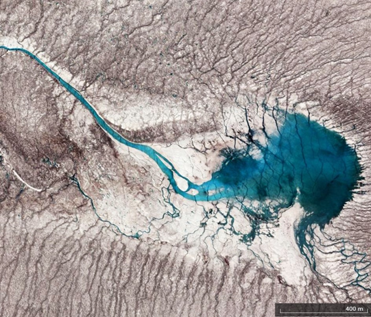
On the Greenland Ice Sheet, supraglacial lakes are abundant and widespread, typically forming at lower elevations at the beginning of the melt season and extending further inland as the melt season progresses (21).
Drainage of Greenland Ice Sheet supraglacial lakes
Supraglacial lakes have attracted a lot of attention on Greenland due to their unusual drainage behaviour.
Supraglacial lakes can rapidly empty via a process called hydrofracturing (stress-induced cracks in the ice surface that can reach the bed), draining large volumes of meltwater to the ice bed in the space of a few hours, which can influence ice dynamics (4,22-23) (figure 4).

In West Greenland, up to 45% of all supraglacial lakes drain in this way (19) and observations from satellite images have also observed the occurrence of ‘cascade events’, where supraglacial lakes drain in clusters due to larger stresses (24).
The presence and drainage of supraglacial lakes across ice shelves and ice tongues can also be a sign of instability, a prime example being the fracture and sudden collapse of the Larsen B Ice Shelf in Antarctica in 2002 (25).
The ponding of meltwater in supraglacial lakes also affects how reflective the Greenland ice surface is (known as albedo). As they are darker than the surrounding ice, they reduce local surface albedo leading to more melt being produced (26). With additional melt at the surface available for runoff and storage in lakes, the ice surface continues to darken, driving a positive feedback mechanism (27).
Where on the Greenland Ice Sheet do we find these supraglacial features?
Supraglacial channels and lakes are found right across the ablating (melting) margins of the Greenland Ice Sheet and interestingly, can look very different depending where on Greenland you look.
Western Greenland
In the western regions of Greenland, the supraglacial hydrologic system has a ‘trellis-like’ drainage structure, with hundreds of short, branching supraglacial channels interconnected with supraglacial lakes, often flowing ‘transverse’ to ice direction (28-29) (figure 5). Moulins are common here up to an elevation of 1500m (1) and so can interrupt the flow of melt before reaching the ice edge.
This ‘compact’ drainage system can lead to meltwater being quickly evacuated from the surface in a rapid and ‘flashy’ way (1,7), which has been attributed to periods of ice acceleration in these regions, particularly at the beginning of the melt season when the subglacial hydrologic system is ‘inefficient’ (meaning the plumbing system that evacuates melt underneath the glacier is overwhelmed by surface melt, causing basal water pressure to increase) (30-31).

Northwest Greenland
If we then look at the surface hydrologic system in another region of Greenland, for example in the north west at Inglefield Land, we see a very different drainage structure (figure 6).
Here, the supraglacial hydrologic system has straighter, more densely-packed supraglacial channels that are parallel to ice flow, with few supraglacial lakes (except for at their source). The lack of moulins here due to colder-based, thicker ice also allows these rivers to flow undisturbed, stretching for 50 km+ in length from the ice interior to the ice edge (32).
This longer, more elongated drainage system means meltwater takes longer to be transported and evacuated, entering the ocean more gradually (6).

About the Author
Lauren is a glaciology PhD student at the University of York interested in ice sheet hydrology and the impacts of contemporary climate change on glaciated environments. Her PhD focuses on mapping and examining the evolution of supraglacial channels on the Greenland Ice Sheet at a range of spatial and temporal scales using both remote sensing and UAV applications.

Lauren’s interests also lie in teaching and science communication, with her being actively involved in outreach education.
Twitter – @Lauren_Rawlins1
Website – https://www.york.ac.uk/environment/our-staff/lauren-rawlins/