Answers to questions asked through Ask A Scientist are posted here. Questions are answered by Bethan Davies or someone from the AntarcticGlaciers team.
Is there any evidence to show that glaciers have been shrinking due to global warming?
Asked by Jack
Hi Jack,
Glaciers are shrinking world-wide, and the rate of recession is generally increasing. It is difficult to relate the behaviour of individual glaciers to climate change, but the general trend of accelerating recession is indicative of a world-wide response to global warming. Glaciers are a 'natural thermometer', as their changes are the result of an integrated response to climate.

This figure shows the global distribution of glaciers. The diameter of the circle shows the area covered. The area covered by tidewater glaciers is shown in blue. The number refers to the RGI region. From the IPCC AR5 Working Group.
We see glaciers shrinking particularly rapidly around the Antarctic Peninsula and I've written about Antarctic glacier recession here. Worldwide, the glaciers in Alaska, the Canadian Arctic, around the periphery of the Greenland Ice Sheet, the Southern Andes and the Asian mountains are shrinking fastest. We can observe and map glaciers and their recession by using satellite remote sensing. Observations of length changes generally show strong glacier recession.

Selection of long-term cumulative glacier length changes as compiled from in situ measurements. From the IPCC AR5 Chapter 4.
The IPCC Assessment Report 5 has a good summary:
Since AR4, almost all glaciers worldwide have continued to shrink as revealed by the time series of measured changes in glacier length, area, volume and mass (very high confidence).Measurements of glacier change have increased substantially in number since AR4. Most of the new data sets, along with a globally complete glacier inventory, have been derived from satellite remote sensing.
Between 2003 and 2009, most of the ice lost was from glaciers in Alaska, the Canadian Arctic, the periphery of the Greenland ice sheet, the Southern Andes and the Asian Mountains (very high confidence). Together these regions account for more than 80% of the total ice loss.
Total mass loss from all glaciers in the world, excluding those on the periphery of the ice sheets, was very likely 226 ± 135 Gt yr–1 (sea level equivalent, 0.62 ± 0.37 mm yr–1) in the period 1971–2009, 275 ± 135 Gt yr–1 (0.76 ±0.37 mm yr–1) in the period 1993–2009, and 301 ± 135 Gt yr–1 (0.83 ± 0.37 mm yr–1) between 2005 and 2009.
Current glacier extents are out of balance with current climatic conditions, indicating that glaciers will continue to shrink in the future even without further temperature increase (high confidence).
How are ice cores dated?
I was wondering how ice cores are dated accurately. I know Carbon 14 is one method, but some ice cores go back hundreds of thousands of years. Would other isotopes with longer half-lives be more accurate?
Also, how much does it cost to date the core? How are samples acquired without destroying the ice? I imagine keeping the ice intact as much as possible would be extremely valuable.
Some of the answers to these questions are available on the Ice Core Basics page.
Ice cores can be dated using counting of annual layers in their uppermost layers. Dating the ice becomes harder with depth. Other ways of dating ice cores include geochemisty, wiggle matching of ice core records to insolation time series (Lemieux-Dudon et al. 2010), layers of volcanic ash (tephra) (Vinther et al., 2006), electrical conductivity, and using numerical flow models to understand age-depth relationships (Mulvaney et al., 2012), combined with firn densification modeling to estimate the delta-age (Lemieux-Dudon et al. 2010). Usually multiple methods are used to improve accuracy.
Common global stratigraphic markers are palaeo-events that occur worldwide synchronously, and can allow wiggle-matching between ice cores and other palaeo archives (e.g., marine sediment cores). For the ice matrix, these global stratigraphic markers can include spikes in volcanic ash (each volcanic eruption has a unique chemical signature), or volcanic sulfate spikes. For the gas phase, methane, and oxygen-18 isotopic ratio of O2 have been used (Lemieux-Dudon et al. 2010).
Uranium has been used to date the Dome C ice core from Antarctica. Dust is present in ice cores, and it contains Uranium. The decay of 238U to 234U from dust in the ice matrix can be used to provide an additional core chronology. Beryillium-10 has also been used to date ice cores.
Ice cores are expensive to collect, house and keep. They must be stored continuously at a specific temperature. The American National Ice Core Laboratory provides some information on how they store and keep ice cores.
When ice cores are analysed, they may be cut or sectioned, with half the sample remaining as an archive. As the ice must be melted for analysis, the sample is usually destroyed during analysis.
 Typical CPL cut plan for a large multi-investigator ice coring project such as the WAIS Divide Ice Core project. —Credit: NICL-Science Management Office
References
Lemieux-Dudon B, et al. Consistent dating for Antarctic and Greenland ice cores. Quaternary Science Reviews 29, 8-20 (2010).
Mulvaney R, et al. Recent Antarctic Peninsula warming relative to Holocene climate and ice-shelf history. Nature 489, 141-144 (2012).
Vinther BM, et al. A synchronized dating of three Greenland ice cores throughout the Holocene. Journal of Geophysical Research: Atmospheres 111, n/a-n/a (2006)
What is the official term to describe a group of icebergs?
Asked by Andrea
Well Andrea, this really got a lot of attention when I surveyed a group of my glaciology colleagues. There is no 'official' term, but there are some commonly used phrases,often taken from nautical terms, like 'armada' or 'flotilla'. Armada is more often used for a very large group of icebergs (such as Heinrich Events in the North Atlantic deep sea sediment record), and is a general term for a large group of floating objects gathered together. For smaller groups, people have used swarm, cluster, fleet, litter or drift. A group of icebergs circulating in an oceann current could be a gyre of icebergs. Grounded icebergs, that are not free floating, could be a shoal of icebergs. I think all of this is very emotive and beautiful.
There are some terms that have a very specific meaning. A melange is a mixture of frozen sea ice, icebergs, growlers and bergy bits (small icebergs) that exist within a fjord, at the margin of a calving glacier. The melange provides some back stress that supports the calving margin.
[caption id="attachment_6039" align="alignnone" width="300"] Iceberg near Rothera, Antarctic Peninsula[/caption]
Learn more about icebergs here: https://www.antarcticglaciers.org/glacier-processes/glacier-types/icebergs/
Are there glaciers at the South Pole?
Asked by Olivia
Hi Olivia,
In fact, there are no glaciers at the South Pole. There is however a great ice sheet; ice sheets are masses of ice greater than 50,000 km2. At the South Pole, the East Antarctic Ice Sheet is hugely thick, with the ice flowing slowly towards the coast.
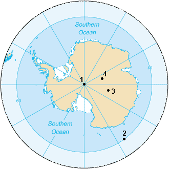
The image below shows the Amundsen-Scott South Pole Station, with the ceremonial South Pole and the flags for the original 12 signatory nations of the Antarctic Treaty.

The South Pole is at 2835 m above sea level and lies 1300 km from the nearest open water (in the Bay of Whales). The East Antarctic Ice Sheet is 2700 m thick here. The South Magnetic Pole is where the Earth’s geomatnetic field lines are pointed vertically upwards. The South Geomagnetic Pole is the point where the axis of a best-fitting tilted dipole (like a bar magnet) placed at the centre of the Earth intersects the Earth’s surface in the southern hemisphere.
The South Pole in Antarctica may be hard to get to, but not as hard as the South Pole of Inaccessibility. This is the most remote place in Antarctica, being furthest from all coastlines. It is 878 km from the South Pole, 3718 m high (different means of measurement do place the South Pole of Inaccessibility in slightly different places).
The image below shows:
- South Geographic Pole,
- South Magnetic Pole (2007),
- South Geomagnetic Pole,
- South Pole of Inaccessibility
Did Lake Vostok exist prior to the Antarctic glaciation, or was it formed as a result of the formation of the Ice Age?
Subglacial Lake Vostok is a lake occupying a topographic hollow beneath the Antarctic Ice Sheet. Water occurs at high pressure beneath the Antarctic Ice Sheet and accumulates in topographic hollows. This hollow may have formed during pre-glacial or glacial times and is tectonically controlled. So, a lake may or may not have formed here during pre-glacial times and it is likely to have been below sea level. It has been continuously covered with ice for at least the last 15 million years.
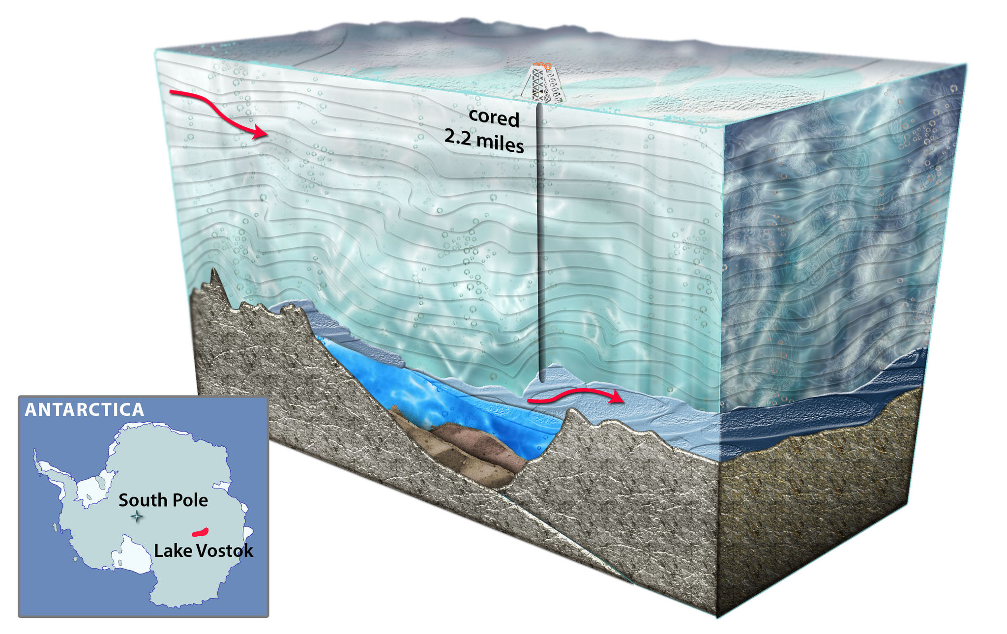
The image above is a cartoon of drilling into Lake Vostok. By Nicolle Rager-Fuller/ NSF.
Some statistics about the lake:
- Surface elevation: -500 m
- Area: 15,690 km²
- Length: 250 km
- Width: 50 km
- Mean depth: 344 m
More information here.
On average how long does it take for a glacier to build up before it starts to slowly move and slide? And how do Newton's Laws affect a glacier the most?
Asked by Erik
Hi Erik,
The time taken for glacier ice to thicken sufficiently to start to move downslope will depend on:
- The rate at which snow builds up
- The slope of the ground.
Small, simple glaciers are driven by the gravitational driving force ( τb), as given by the equation:
τb = ρigh sin αS
Where ρigh is the density of the ice (ρi), g is the acceleration due to gravity, and h is the thickness of the ice. This part of the equation is derived from Newton's Second Law (F = ma), where the mass of the ice is the density times the height and the acceleration is the acceleration due to gravity.
αS is the ice surface slope. Steeper slopes tend to result in faster-flowing glaciers. The gravitational driving stress is resisted by basal and lateral drag against the valley floor and walls.

See more information on how glaciers flow here.
Why is it that generally lateral and medial moraines get washed away after a glacier melts, yet eskers do not?
Asked by Samuel,
Hi Samuel,
This essentially comes down to preservation potential of landforms. Eskers underneath ice sheets can be quite large features, filled in with sand and gravel. As a result, after ice-sheet recession, they form fairly robust features that can withstand post-glacial processes of wasting and redeposition. One of the most famous eskers in the UK is the Blakeney Esker in Norfolk.
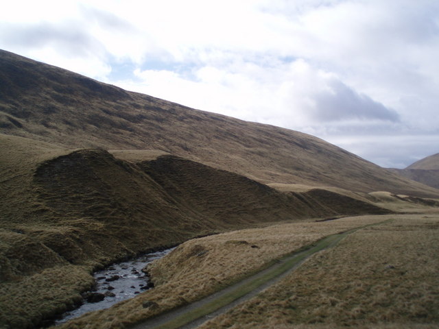
Lateral moraines are preserved in the landform record, but are often quite subtle features plastered onto hillsides, so are perhaps less obvious than large, prominent terminal moraines. The photograph below is an example of a lateral moraine at Glen Isla in Scotland. The river Isla, close to its source at this point, has cut away at the lateral moraine deposits. From www.Geograph.org.uk.
 In contrast, medial moraines are often quite small, superficial features, resulting from supraglacial debris falling onto the glacier. In the photograph below, you can see that one of the medial moraines starts below a rocky outcrop, from rocks falling onto the glacier surface. They are therefore likely to contain less debris, and have less preservation potential, than a terminal moraine that is built up over a longer period of time in one position.
Medial moraines may also form where two glaciers join, but again, although they look striking on the glaciers, they are unlikely to result in pronounced landforms once the glacier melts. Most of the debris will just end up building up at the terminal moraine position.
In the aerial photograph below, you can see medial glacier moraines on the Nuussuaq Peninsula, Greenland. Medial moraines, which form on the glacier surface, may be ice-cored, which makes them seem like they contain more debris than they actually do. From Wikimedia Commons.

Do you still feel the cold through the many layers of clothing that you wear?
Question:
Hello, we are 25 Primary 5 pupils from Inverness. We are studying Antarctica as our topic and would love to communicate with a scientist who has worked in Antarctica. We hope you can answer some of our questions.
Do you still feel the cold through the many layers of clothing that you wear?
Is it hard/slippy to walk on the ice?
Are you able to eat fresh fruit and vegetables or is the food you eat all from packets?
Is it cold inside or do you have heaters?
How long do people stay in Antarctica and is it hard living there? What do you do in your spare time?
What is your job in Antarctica?
Thank you for helping us
Primary 5
Hello Primary 5,
I was thrilled to receive these questions! Here I have tried to answer each one.
Do you still feel the cold through the many layers of clothing that you wear?
Antarctic scientists wear lots of layers that are designed to keep us warm when we're working outside. One of the most important is a down jacket filled with warm feathers, which keeps us cosy even when it's well below zero! The images below shows us working when it was about -25 degrees Celsius, but the warm jackets, gloves, hats, buffs and scarfs keep us warm.
 Mike Hambrey and Bethan Davies working in Antarctica. Photo credit: Ian Hey.
Below: Ian and Mike Hambrey on a moraine. Photo credit: Bethan Davies.

We do still sometimes get cold of course, but we quickly warm up with a thermos of coffee or tea and some chocolate! We also sometimes take breaks in a bothy, which is like a tent that you can put up very quickly and shelter in.
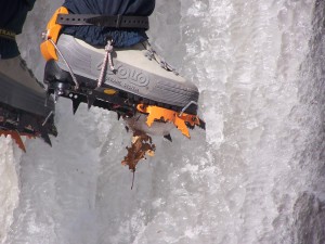
Is it hard/slippy to walk on the ice?
The ice can be very slippery to walk on, so we wear crampons on our feet when walking on ice. They have sharp metal teeth that bite into the ice and stop us from slipping over. The image below shows someone ice climbing using crampons (from Wikipedia).
 Are you able to eat fresh fruit and vegetables or is the food you eat all from packets?

When we are working deep field, away from the research bases, we only eat food from packets. So no fresh food or vegetables! This is because they are heavy and go off quite quickly. Weight is very important as everything must be flown in or carried in to the field site.
When we are working on a research base, like Rothera, fresh food is available in the summer months when the bases are supplied by a ship. Bases are not supplied in the winter however, and so once the 'freshies' run out, that's it! No more vegetables until the next ship arrives in the spring!
Is it cold inside or do you have heaters?
The research bases are very warm and cosy inside. They are well insulated and have heaters so you only need to wear clothes like you might at home in the winter. When we're camping in the field, we can use primus stoves to warm up the tent. The image below shows our three-man tent that we camped in for two months.
 It is very cosy inside the tent, once you have lit the primus stove and tilly lamp. It is all rather comfortable! In the image below you can see a pot coming to the boil on the primus stove. The paraffin tilly lamp is hanging up, giving us light and heat.

How long do people stay in Antarctica and is it hard living there? What do you do in your spare time?
Research bases, like Rothera, must be manned all year around. So some people will go to Antarctica for up to 18 months to work on the bases. This includes people like plumbers, engineers, doctors, scientists, chefs, meteorologists, and all sorts of other people! Life can be hard as they do not get to see their family for all of the time that they are there.
Other scientists, like me, can only work in the summer in Antarctica. So I only ever go down for up to three months at a time.
When you're on the base, you work a normal working week and have plenty of spare time. People use the internet, socialise with their friends, go for a walk, play games and cards, go skiing or sledging, ice climbing and all sorts of other activities in their time off. There is plenty to do! And there are always penguins to look at! The animals are often around the base and always provide entertainment. Here is an elephant seal outside my sleeping quarters!

What is your job in Antarctica?
I'm a glacial geologist so I go to Antarctica to study the evidence for ancient glaciers. I'm interested in how past glaciations shaped the landscape in Antarctica and what that can tell us about how glaciers respond to climate change. The picture below shows me working deep field in Antarctica!
 Thank you for asking me all your questions!
Are there debris-covered glaciers in Antarctica? And if so, where are they?
Asked by Pierre
Debris-covered glaciers, those glaciers with layers of rock and debris on their surface, occur world-wide. They form part of a continuum with other icy, rocky features, such as rock glaciers. Debris-covered glaciers and rock glaciers both flow, resulting in their lobate forms. Rock glaciers are one end-member, with higher amounts of debris held together largely by interstitial ice, and clean ice is at the other end of the spectrum, with very little debris on the ice surface. The proportion of rock and ice within and on top of the ice is highly variable.
Debris-covered glaciers and rock glaciers
Debris-covered glaciers and rock glaciers form when a high amount of debris falls on the ice surface. Debris-covered glaciers are not known from the interior of the Antarctic Ice Sheet, because the large ice sheet overwhelms local topography, meaning that a steady supply of rock is not available. To find them, we must look to the fringes of the Antarctic Ice Sheet.
Rocks glaciers on the Antarctic Peninsula

Rock glaciers are common on the Antarctic Peninsula, particularly on James Ross Island1, as shown in the photograph above. They form here at the base of scree slopes, and extensive periglacial activity ensures a steady supply of rocks. I have also observed them on Alexander Island, at Fossil Bluff.
Debris-covered glaciers in the Dry Valleys
The other place where debris-covered glaciers occur is in the Dry Valleys of East Antarctica2. Compared with the Antarctic Peninsula, this area receives very little precipitation and the glaciers flow very slowly. Some of the glacier ice is millions of years old. Because of the limited precipitation, rocks falling steadily onto the surface of the glaciers builds up, resulting in debris-covered glaciers.
1. Davies, B.J., Glasser, N.F., Carrivick, J.L., Hambrey, M.J., Smellie, J.L., & Nývlt, D. Landscape evolution and ice-sheet behaviour in a semi-arid polar environment: James Ross Island, NE Antarctic Peninsula. in Antarctic Palaeoenvironments and Earth-Surface Processes, M.J. Hambrey, P.F. Barker, P.J. Barrett, V.C. Bowman, B.J. Davies, J.L. Smellie, and M. Tranter, Editors. 2013, Geological Society, London, Special Publications, volume 381: London. 353-395.
2. Shean, D.E. &Marchant, D.R. Seismic and GPR surveys of Mullins Glacier, McMurdo Dry Valleys, Antarctica: ice thickness, internal structure and implications for surface ridge formation. Journal of Glaciology. 56, 48-64 (2010).
What kind of topographic features lie beneath the Antarctic Ice Sheets?
What kind of topographic features lie beneath the Antarctic Ice Sheets? Is it mostly similar to what we have in North America, or are there new features we haven't seen before?
Asked by Samuel.
Hi Samual,
The Antarctic continent is usually divided up into three sectors: East Antarctica, West Antarctica and the Antarctic Peninsula. Each region has its own characteristics. We can look beneath the ice with radar, and as a result have built up a pretty good understanding of the topography beneath Antarctica. BEDMAP is a major initiative that has compiled all available ice-bed data, and you can see the results in the image below.
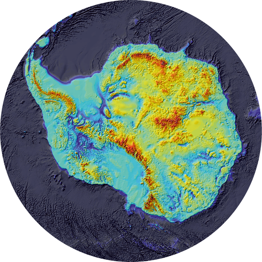 BEDMAP 2, showing that the bedrock on which the West Antarctic Ice Sheet rests is well below sea level.
Underneath the ice, the Antarctic Peninsula is a spine of mountains projecting northwards from the Antarctic continent. West Antarctica is actually grounded mostly below sea level; if all the ice disappeared, most of this would be ocean. East Antarctica, the largest sector of Antarctica, includes flatter plains and shield areas as well as mountains. The Gamburtsev Mountains are buried under thousands of metres of relatively cold ice, which have preserved a pre-glacial landscape. The mountain valleys resemble a pattern of river drainage.
 Location of the AGAP survey in East Antarctica (left) and the sub-ice topography of the Gamburtsevs (right) within the central AGAP survey grid (182,000 km2). The topography has been corrected to account for the removal of the ice sheet, so that elevations reflect those under ice free conditions, prior to glaciation. Note: LV – Lake Vostok. Image by Kathryn Rose.
The news about the effect of climate change in the Arctic centres on the loss of polar bears. Will there be a similar effect with wildlife in the Antarctic?
Parts of Antarctica are warming rapidly, and this is affecting snowfall, snowmelt, sea ice distribution and thickness, and ice shelves. Different species are affected in different ways by these processes.
Emperor penguins are often cited as one of the most vulnerable animals. Over the past 50 years, the population of Emperors in Terre Adelie has decreased by 50% because of a decrease in adult survival during the late 1970s, when there was a prolonged warm period with decreased sea-ice extent (Barbraud and Weimerskirch, 2001).

Emperor penguins. By Ian Duffy from UK - Animal PortraitsUploaded by Snowmanradio, CC BY 2.0
Across the Western Antarctic Peninsula, winter temperatures are increasing and sea ice extent is decreasing, both of which profoundly affect the ecosystem. This has affected the krill population in the area, as krill are dependent on winter sea ice. Krill forms the basis of the Antarctic food chain and is a staple food for both Chinstrap and Adelie penguins. As krill abundance decreases, Adelie and Chinstrap penguin populations continue to decline (Trivelpiece et al., 2011).

Antarctic krill. By Øystein Paulsen - MAR-ECO, CC BY-SA 3.0
References
Barbraud C, Weimerskirch H. Emperor penguins and climate change. Nature 411, 183-186 (2001).
Trivelpiece WZ, Hinke JT, Miller AK, Reiss CS, Trivelpiece SG, Watters GM. Variability in krill biomass links harvesting and climate warming to penguin population changes in Antarctica. Proceedings of the National Academy of Sciences 108, 7625-7628 (2011).
Pingback: 南極有冰山嗎? - 知識星球