What is a glacial erratic?
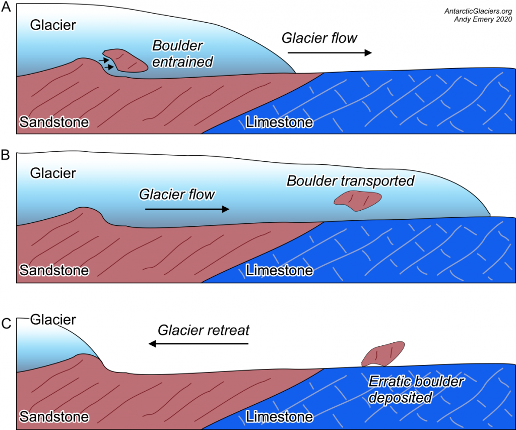
Glacial erratics, often simply called erratics, or erratic boulders, are rocks that have been transported by ice and deposited elsewhere. The type of rock (lithology) that the glacial erratic is made from is different to the lithology of the bedrock where the erratic is deposited.
For example, an erratic could be a boulder of sandstone is picked up by a glacier, transported, and deposited on top of a limestone bedrock. Some erratics are useful to scientists because they are of a distinctive rock type, which means that their source outcrop can be identified and located. Glacial erratics are therefore useful in reconstructing past glacier flow directions, the timing of glacier retreat, and even the type of glacier flow.
Where do glacial erratics come from?
As a glacier or ice sheet moves, it can erode bedrock. The ice can then pick up, or entrain, the eroded rock. As the ice flows, it transports the bedrock debris in the direction of flow. The ice then deposited the entrained sediment once it begins to retreat.
Erratics can range from large boulders to smaller stones and pebbles. All erratics are of a different rock type. Glacial sediments often contain a range of rocks of different kinds, which can be used to reconstruct the ‘provenance’1, or source, of the sediment and therefore the direction of ice flow.
Rocks that are moved by the glacier but are of the same rock type are called ‘glacially-transported’ rocks. All glacially-transported rocks and erratics tend to show evidence of that glacial transport, with scratches (striations), rounded edges and polished faces.

Glacial erratics and glacially-transported rocks can be sourced from rocks falling onto the glacier, rocks being picked up and transported at the base of the glacier, and rocks plucked from valley sides. Rocks transported on the glacier surface are said to be ‘supraglacial’, whilst rocks transported at the base of the ice are ‘subglacially’ transported.
What do glacial erratics tell us about past ice sheets?
The first thing erratics can tell us about past ice sheets is the direction of ice movement. If you find an erratic with a distinctive lithology, you can trace it back to the location where the distinctive bedrock is found.
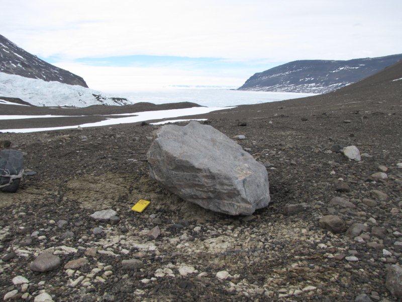
A good example of this indicator lithology in England is the Shap Granite from Cumbria. Boulders of Shap Granite are found throughout Cumbria, County Durham, North Yorkshire and as far southeast as Bridlington on the Yorkshire Coast2,3. The example shown in the figure below is from Goldsborough Carr in County Durham, which is 40 km east of the Shap Granite.

Erratics can tell us when the ice sheet retreated, by cosmogenic dating of the boulder. Assuming the boulder was eroded at the base of the glacier, the exposure age given by the cosmogenic dating will tell us when the boulder was deposited by the retreating glacier4. The boulder of Shap Granite in the figure above was deposited by the retreating Eden-Stainmore Ice Stream approximately 19,750 years ago5.

We can also learn the style of ice-sheet flow from how glacial erratics are grouped. Long lines of glacial erratics are known as dispersal trains. These dispersal trains can show whether flow was focussed into ice streams or as part of a regional, sustained flow6. Boothia-type dispersal trains show that flow over an indicator lithology was focussed into an ice stream, named after the Boothia Peninsula in Arctic Canada. Dubawnt-type dispersal trains have little change in width, which shows that regional, unconstrained flow was active over the indicator lithology.

Where can you find glacial erratics in the UK?
There are many famous examples of glacial erratics in the UK. These erratics have captured the imagination of amateur and professional geologists for centuries. In 1928, the Yorkshire Geological Society published the work of Frederic Harmer7. This map collated the studies of the Yorkshire Boulder Committee and many similar groups.
As you can see below, the map shows the huge density of glacial erratics in the UK. The Norber erratics in the Yorkshire Dales, near Austwick, Settle, are famous and scenic examples of erratics. More examples of erratics are the Great Stone of Fourstones on the Lancashire/Yorkshire border, and Cloughmore in County Down, Northern Ireland.

Reproduced from Harmer 1928, Proceedings of the Yorkshire Geological Society, Vol. 21, 79-150, by permission of the Yorkshire Geological Society.
Scotland is full of glacial erratics thanks to its diverse bedrock geology. We use these erratics to reconstruct the dynamics of the British-Irish Ice Sheet. The figure below shows Dubawnt-style dispersal trains in the Assynt region of Scotland. The outcrops of Torridonian Sandstone and the trains of dispersed erratics show that ice flowed towards the west-northwest. The constant width of the dispersal trains shows that the regional flow of ice was a constant velocity over this area8.

(https://www.ordnancesurvey.co.uk/business-government/products/terrain-5).