Introduction | Supraglacial hydrology | Englacial hydrology | Subglacial hydrology | Proglacial drainage | References | Comments |
Introduction
Glacier hydrology is the study of the flow of water through glaciers. It is a mysterious world, where water running on the surface of the glacier disappears through cracks and holes in the glaciers, and powerful rivers emerge from the glacier snout[1]. Beneath the Antarctic Ice Sheet, these subglacial drainage channels are connected to numerous subglacial lakes[2, 3].
The flow of water at the ice-bed interface has important implications for glacier flow, as saturated subglacial sediments have a low shear strength, and deform easily (see Glacial Processes). Glaciers may also slide over water-saturated subglacial sediments.
You can explore more about Glacier Hydrology in this excellent ArcGIS Story about glacier lake hazards in Alaska.
Impermeable glacier ice
Glacier ice is slightly permeable[1], with a network of microscopic veins and lenses of water[4]. The rate at which water percolates through the glacier is dependent on salinity, pressure and temperature. Meltwater percolates only very slowly, and variations in the rate at which it is able to seep through the ice results in ponded water within and beneath the ice sheet. The rate at which ice seeps through the ice, however, is so slow, that for practical reasons ice can generally be considered impermeable[1].
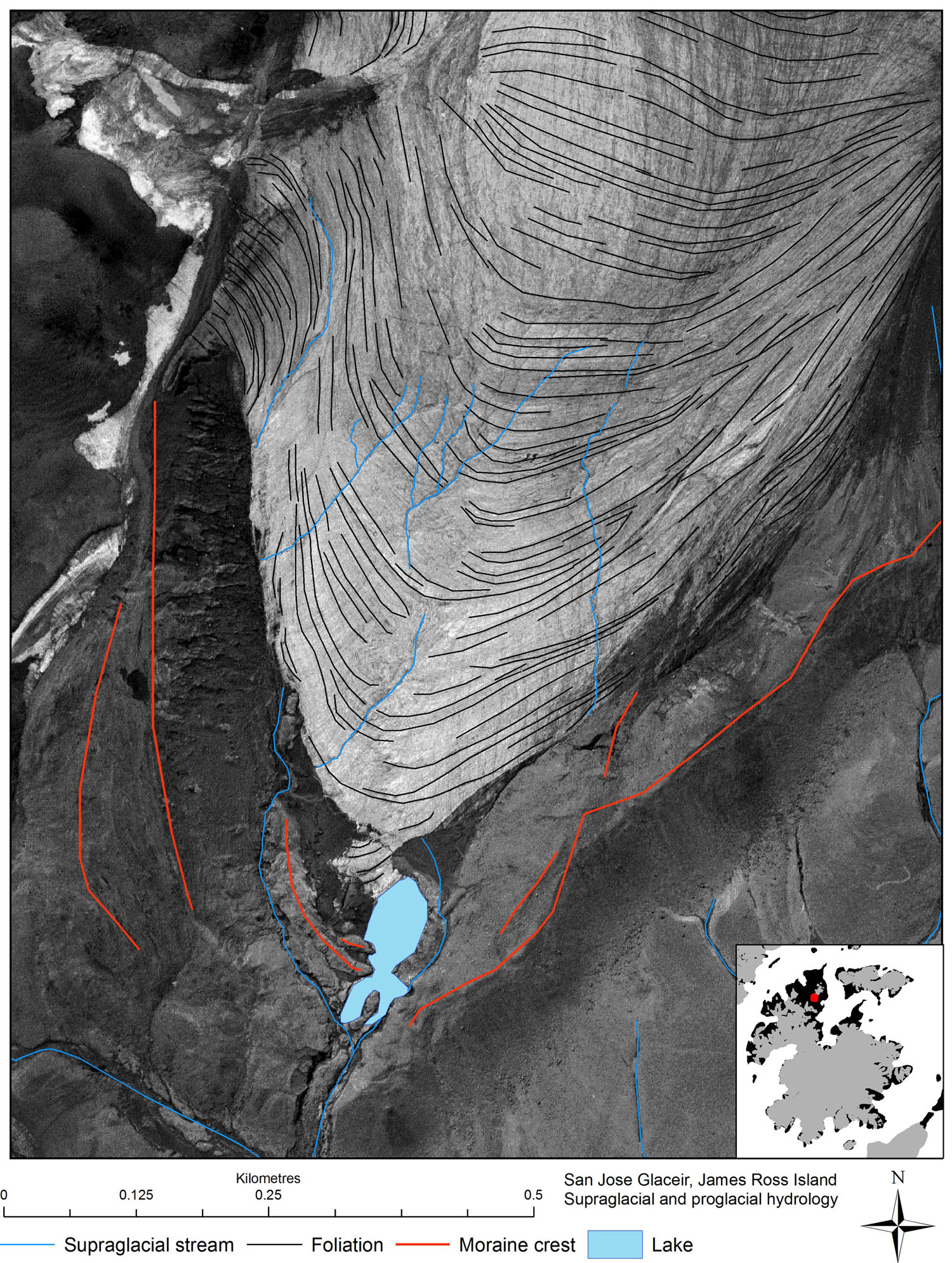
In the next sections, we will discuss supraglacial, englacial and subglacial hydrology with particular reference to Antarctic glaciers.
Supraglacial hydrology
Supraglacial (surface) water on a glacier is formed by the ice melting during the summer. It flows off the glacier, incising a number of cracks similar to an ordinary river system[1]. These channels are often sinuous, and the water can flow at rates of up to several metres per second.

Surface melt (ablation) occurs in the hard-packed snow (firn; the transitional state between snow and ice), and can pond above the impermeable ice.
If the firn becomes saturated all the way to the surface, it becomes a ‘swamp zone’, with puddles of standing water.
The swamp zone moves up glacier as the melt season progresses. The surface drains increasingly quickly as more ice is exposed, and the firn is filled with water[1].
Supraglacial lakes
In Greenland, large lakes form on the surface of the ice sheet during the summer. However, in Antarctica, much of this saturated firn refreezes, making little overall contribution to melt runoff[5]. Much of the meltwater runoff in Antarctica is restricted to coastal areas and ice shelves during the summer seasons.
Saturated firn on ice shelves may facilitate ice shelf collapse[6]. See photographs of meltwater ponds on McMurdo Ice Shelf and this article on supraglacial lakes in Antarctica.
Englacial hydrology
Structures in the ice produced by tension, such as crevasses, allow the water to penetrate into the ice. There are some great examples of this in Greenland, where large lakes can abruptly drain into the ice sheet.
Moulins are vertical shafts cut by the water. Water cascades down these into the ice sheet. Despite the pressures within the ice sheet, moulins remain open by constant melting by the water[1].

Finally, there are numerous water pockets and channels within temperate ice sheets[4] and glaciers, where water can remain trapped for some time.
Subglacial hydrology
Subglacial channels
Subglacial hydrology is critically important in understanding the flow of glaciers. Basal meltwater flows through large subglacial hydrological networks[7], which can impact glacial erosion and ice velocity.
In Antarctica, some of these channels can be followed for hundreds of kilometres. There is evidence that this hydrological system is very variable, with changes within the glacier bed observed underneath Antarctic ice streams[8].
Meltwater reaches the base of ice sheets through basal melting from geothermal heating and by ice melting under pressure from the weight of the ice mass above. Secondly, downwards percolation and flow of supraglacial and englacial systems.
There are several main aspects of the basal hydrological system. Firstly, water can be ponded in subglacial lakes. It can also flow through subglacial channels. R-Channels are incised upwards into the ice. Channels can also be incised into the bedrock or subglacial sediments (Nye channels).
Subglacial lakes
Meltwater can pond in depressions underneath glacier ice. Surface meltwater can reach the bed through moulins, or basal melting due to geothermal energy or pressure melting.
There are numerous subglacial lakes in Antarctica[1]. These subglacial lakes can be overlain by thousands of metres of ice, and are interconnected, with water flowing from lake to lake. These subglacial lakes can influence ice flow, by lubricating the bed of the ice sheet or glacier and encouraging basal sliding.
![379 subglacial lakes have now been identified beneath the Antarctic continent. This map, using data from Wright and Siegert 2012 [1] shows that many are located in ice-stream onset zones as well as underneath slow-moving ice domes.](https://www.antarcticglaciers.org/wp-content/uploads/2013/06/Antarctic_subglacial_lakes.jpg)
Proglacial drainage
Proglacial lakes
The proglacial area of temperate glaciers is characterised by abundant meltwater runoff from the glacier. Often, this becomes impounded in the overdeepened glacier basin as a proglacial lake.

Proglacial lakes may be formed where ice dams the local drainage, or may be dammed by moraines, or by bedrock. These lakes can be an important control on ice dynamics, as they can influence mass balance by causing calving of icebergs. Proglacial lakes can also be hazardous, as unstable moraine dams may fail, causing a glacier-lake outburst flood.

Sandur
Abundant meltwater can form large braided river plains, or sandur. Runoff is less in Antarctica, and meltwater in the northern Antarctic Peninsula tends to be restricted to small braided streams. These streams, which are part of the paraglacial environment, move and redeposit glacial sediments and rework glacial landforms.

Pingback: Monckton in NZ: tells lies on radio, threatens academics and journalists
Pingback: Glacier hydrology an introduction | ClimateState
Very helpful for my school project!
Same I was on here for Science Olympiad. The diagram was great! Thx 🙂
same here, helped a lot, which school are you competing for?
Pingback: Blood Falls: Antarctica's Mysterious Crimson Cascade - Prince EA | Filmmaker, Speaker, Creator
Thanks for sharing
Pingback: Alaska’s Brand New Island – Chiliwap News – AI Curated content