This article was written by Dr Hannah Bickerdike.
The glaciation of the upland areas of Britain during the Younger Dryas left behind a distinctive system of landforms across Scotland, the Lake District, Snowdonia and the Brecon Beacons. Different parts of Britain were characterised by a different style of glaciation. See more on our Introduction to glacial landsystems of the Younger Dryas page.

The areas of thickest ice, under the main icefield, were part of an ice cap landsystem. Where ice was a little thinner, and ice flow was more constrained by topography, there was a plateau icefield landsystem. This is described and discussed in this article.
More mountainous areas, with steep sided mountains and valleys, were part of an alpine icefield landsystem. And around the fringes of the main ice masses, cirque glaciers formed part of a cirque glacial landsystem.
Plateau Icefield landsystem
Evidence of the plateau icefield landsystem is found in various upland areas where the high ground takes the form of a gently undulating area of rounded summits. Valleys usually radiate outward from, and sometimes incise through, the upland area. The more gently rolling topography associated with the plateau icefield landsystem contrasts with the more dramatic relief where evidence of the alpine icefield landsystem is often found.
Examples of areas where evidence of the Loch Lomond Stadial plateau icefield landsystem can be found include the Monadhliath mountains and Gaick plateau in the Central Highlands of Scotland, the Tweedsmuir Hills in the Southern Uplands, Scotland, and areas of the English Lake District.
In these locations, the plateau surfaces were largely covered by ice, although some summits remained above the ice as nunataks. Ice from the plateau drained into the surrounding valleys, where the flow and shape of the glaciers became controlled by the topography.

An example of a present-day plateau icefield could be James Ross Island on the northeast Antarctic Peninsula. James Ross Island has a flat upper plateau, with a steep rim. Cirque glaciers form around the edge.

Landforms of the plateau icefield landsystem
The diagram below shows the types of landform usually found in the Loch Lomond Stadial plateau icefield landsystem in Britain. The numbered features are discussed below.

#1. Recessional moraines
The former outlet glaciers which drain plateau icefields are often marked by sequences of recessional moraines (1) arranged in concentric ridges on the valley floors and lower slopes. These moraines indicate that the general pattern of retreat of these outlet glaciers was interrupted by short phases of glacier advance and retreat.

#2. Valley head and plateau moraines
In some cases, moraines in the valleys can be traced back up onto the gently undulating plateau surface at the valley heads (2).
#3. Erosional landforms
Ice‐moulded bedrock and roches moutonnées (3) may also be present at the valley heads, descending from the plateau surface into the valley. The presence of these features shows that glaciers were able to slide over the bedrock, accelerating as they flowed down into the valleys.

#4. Meltwater channels
Ice-marginal meltwater channels (4) may run between the moraines in the valleys but can also extend on to the gently undulating plateau surface itself. Here, they may form extensive networks of channels.
These channels suggest that some sections of the plateau ice were probably frozen to the bedrock underneath, meaning that meltwater had to flow along the margins of the glacier rather than beneath the ice. These features are described as ice-marginal meltwater channels. Where multiple channels are found in concentric arcs, these show different positions the former glacier held as it retreated back to its source.

#5. Periglacial features
Periglacial features, such as blockfields and solifluction lobes (5) may be present on the higher summits of the plateau.

Case Study: Monadhliath Plateau Icefield
The Monadhliath Mountains in the Central Grampian Highlands of Scotland show glacial geomorphology typical of the plateau icefield landsystem. The numbers on the map match with the features described above.
During the Last Glacial Maximum, the Monadhliath Mountains were completely submerged beneath the British-Irish Ice Sheet. During the Loch Lomond Stadial, the area supported a plateau icefield which fed 53 outlet glaciers. The map shows some of the outlet glaciers which drained the south-eastern part of the icefield.
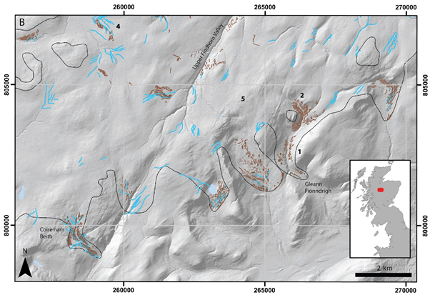
Recessional moraines, indicative of warm-based ice, are found mostly in the surrounding valleys and in some cases extend back onto the plateau.
A large number of ice-marginal meltwater channels are present on the plateau surface and around its edges. These features are indicative of a cold-based glacier ice.
Periglacial features such as blockfields and solifluction lobes are present on some of the plateau summits, including the high ground north of Gleann Fionndrigh. It is uncertain whether the blockfields remained above the glacier surface during the Loch Lomond Stadial, or whether these features were covered and protected by cold-based ice.
The Monadhliath plateau icefield is thought to have been a polythermal icefield as it shows evidence of features created by both warm and cold-based ice.
Summary
In summary, the Loch Lomond Stadial plateau icefield landsystem is found in upland areas of Britain where glaciers formed on gently undulating plateau surfaces and drained into surrounding valleys.
The landsystem contains: sequences of recessional moraines within the valleys which sometimes extend onto the plateau surface; erosional landforms at the valley heads; and networks of ice-marginal meltwater channels.
These icefields may have been polythermal, with areas of both warm and cold-based ice.
Activity
You can explore the glacial landforms of the Monadhlaith Mountains using the Younger Dryas Glacial Map.
Use the map to zoom to the Monadhleith Mountains. Zoom in and out and explore the landforms. Turn the basemap to satellite imagery and investigate the geomorphological evidence for yourself. Can you see the features in the satellite imagery?

Further reading
- Plateau Icefield landsystem of Juneau Icefield
- Introduction to Younger Dryas glacial landsystems of Britain
- Cirque landsystem of upland Britain
- Alpine icefield landsystem of upland Britain
- Cirques (including Snowdonia cast study)
- Younger Dryas Glaciation of Britain
- Younger Dryas Glacial MapBritish-Irish Ice Sheet
About the author
Hannah Bickerdike completed her BSc in Geography at the University of St Andrews. She subsequently undertook a PhD at Durham University, studying the geomorphology of the Loch Lomond/Younger Dryas Stadial glaciers of Britain. A key element of this work was compiling geomorphological evidence of these glaciers, mapped in previous research, into a GIS database of over 95,000 features, a version of which can be found on this site.
