What are meltwater channels?
Each year, glaciers melt. Meltwater channels are erosional features, cut into rock and sediment by flowing water beneath or close to ice-sheet margins1,2. They can cut sizeable troughs, meaning that they are very visual indicators of the location of the former ice margin.
Meltwater channels can therefore be used to work out the location of the ice margin, and help understand the pattern of glacial retreat3, especially in places where moraines are limited. They can also give glacial geologists insights into the thermal regimes of past glaciers. They formed commonly in Britain during the Younger Dryas glaciation.
Different kinds of meltwater channels
Subglacial meltwater channels
Surface meltwater can flow on the surface of the glacier, and perhaps penetrate to the bed of the glacier. The water here may form subglacial meltwater channels.
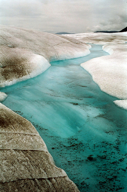
Meltwater can flow under the glacier ice, or around its margins. Where the water can reach the bed of the glacier, it may form a subglacial meltwater channel. These typically have an undulating long profile, and may descend down the slope at an angle. They may not have current streams in them, and can form complex systems that split and meet up again3.

These subglacial meltwater channels may also be called Nye Channels. Again, these are erosional, subglacial features that are cut into bedrock and sediments, underneath the glacier. These features can range from a few tens of metres to thousands of metres long1.
The largest subglacial channels are called Tunnel Valleys. Tunnel valleys can be up to 100 km in length.
Subglacial meltwater channels can form networks, similar to those that form on ground today. Flow is driven by pressure gradients as well as elevation, so these channels can flow uphill and therefore have undulating long profiles1, that go up and down. Channels do tend to avoid high points on the bed, so at a local scale, they will avoid bedrock highs, and will usually form at topographic low points or cols.
Subglacial meltwater channels are associated with temperate, wet-based glaciers that have ice at melting point at their bed2. The presence of subglacial meltwater channels can therefore tell investigators something about the thermal regime of the past glacier.
Ice-marginal / lateral meltwater channels
However, if the stream cannot reach the bed, perhaps because the glacier is frozen to its bed (polythermal or cold-based glaciers), the streams may flow to the sides of the glacier, and follow the glacier edge (the lateral margin), or the snout. Meltwater is forced to go around the glacier1.
In this case, it the water may cut ice-marginal meltwater channels. This is most common for cold-based subpolar or polythermal glaciers, where the meltwater cannot reach the base of the glacier as it’s frozen to its bed. Subglacial meltwater channels do not form here2.
Ice-marginal meltwater channels can track the position of the glacier snout. Once the glacier is gone, the ice-marginal meltwater channels are left behind, often forming nested sequences that mark out the former ice margin (e.g., see geomorphological map below).
The map below shows meltwater channels that formed on a high plateau in the Monadhliath Mountains in Scotland, during the Younger Dryas glaciation4,5. These meltwater channels formed in an ice-marginal position, and where moraines are absent, can be used to trace the ice margin (the snout of the glacier).

Ice-marginal channels can also lie in a lateral position, such as along a valley flank (e.g. see schematic cartoon below). An example of a lateral meltwater channel is shown below in the photograph of a meltwater channel from Lunedale, in the Pennines.

Instead of flowing downhill, lateral meltwater channels are parallel with contemporary contours, and can form a series of channels, parallel to each other3. They are perched on valley sides and may form networks. Lateral meltwater channels can terminate abruptly, or may end in downslope chutes.

Lateral meltwater channels may form in a marginal or sub-marginal position. Marginal meltwater channels form between the glacier and the valley side, but sub-marginal ones form just underneath the glacier, again in a lateral position3.
Lateral meltwater channels have helped to determine the ice surface of an ice stream in the Vale of Eden (Pennines, UK), during the last phases of the last glaciation7. In the figure below, yellow meltwater channels are the subglacial channels that formed underneath the glacier. Lateral meltwater channels formed at the ice margin against the valley side, with blue ones forming at the ice surface and the red meltwater channels being submarginal ones, formed just under the ice.

Proglacial meltwater channels
In front of the glacier, water drains away downslope through proglacial meltwater channels. Meltwater channels may form a braided pattern, and cut through and dissect moraines. Here is an example of some proglacial meltwater channels that formed on the outwash deposits in front of the North Patagonian Icefield during the Last Glacial Maximum.

Proglacial meltwater channels form most commonly where there is abundant meltwater in temperate settings. The meltwater drains away downslope, away from the ice margin2.
Meltwater here usually contains a high volume of sediment, and they typically degrade into a network of shallow, sediment-floored channels separated by gravel bars. These collectively make up an outwash plain or sandar.

Summary
Meltwater channels vary greatly in terms of availability of meltwater, glacier thermal regime, and the local geology or availability of sediment. They can form subglacially, ice-marginally or laterally, or proglacially. They can be used to help understand the position of a former ice margin, and give insights into the glacier’s thermal regime.
How long did melt water channels take to develop? Some surely must have been formed very quickly as melting ice, by definition is essentially short lived on a geological time-scale. Yet they can be dramatic and out of sync with the nature of fluvial valleys.. (I graduated in geography BSc, 1959)
Martin Pask
martin.pask@yahoo.co.uk
Hi Martin. Sometimes they can form very quickly, even annually, following the glacier’s recession. If the margin is stable for some time, then they may be re-occupied each ablation season.