What kind of topographic features lie beneath the Antarctic Ice Sheets? Is it mostly similar to what we have in North America, or are there new features we haven’t seen before?
Asked by Samuel.
Hi Samual,
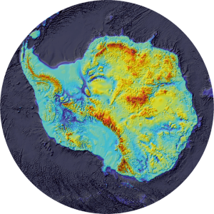
The Antarctic continent is usually divided up into three sectors: East Antarctica, West Antarctica and the Antarctic Peninsula. Each region has its own characteristics. We can look beneath the ice with radar, and as a result have built up a pretty good understanding of the topography beneath Antarctica. BEDMAP is a major initiative that has compiled all available ice-bed data, and you can see the results in the image below.
 BEDMAP 2, showing that the bedrock on which the West Antarctic Ice Sheet rests is well below sea level.
Underneath the ice, the Antarctic Peninsula is a spine of mountains projecting northwards from the Antarctic continent. West Antarctica is actually grounded mostly below sea level; if all the ice disappeared, most of this would be ocean. East Antarctica, the largest sector of Antarctica, includes flatter plains and shield areas as well as mountains. The Gamburtsev Mountains are buried under thousands of metres of relatively cold ice, which have preserved a pre-glacial landscape. The mountain valleys resemble a pattern of river drainage.
 Location of the AGAP survey in East Antarctica (left) and the sub-ice topography of the Gamburtsevs (right) within the central AGAP survey grid (182,000 km2). The topography has been corrected to account for the removal of the ice sheet, so that elevations reflect those under ice free conditions, prior to glaciation. Note: LV – Lake Vostok. Image by Kathryn Rose.
