Ellipsoidal Basins is a geographical term used to describe deep, elongated lakes, formed by subglacial activity beneath past ice sheets [1]. Examples of these basins include the Great Lakes and Finger Lakes of North America [1,2]. These basins were formed either where the ice was topographically constrained (Finger Lakes), had vulnerable, softer, geology (the Great Lakes), or in an area of maximum ice discharge (Hudson Bay) [1].

All these ellipsoidal basins are orientated in the direction of past ice flow and near the ice sheet margin [3]. They have smoothed edges, which is typical of glacial landforms. A more commonly used term to describe this type of lake is glacial overdeepening.
Glacial overdeepenings are large-scale erosional landforms which have been widened and deepened to depths deeper than the pre-glacial valley [4]. Overdeepened basins can be also used to describe other glacial features such as cirques or fjord floors [3,5]. However, here we will be discussing overdeepened basins formed beneath ice sheets (ellipsoidal basins).
Formation of Ellipsoidal Basins
Over the Quaternary Period (the last 2.6 million years), successive cold glacial periods allowed large ice sheets to spread over much of the high latitudes of the Northern Hemisphere, including the Laurentide Ice sheet [4] in North America. The Laurentide Ice Sheet expanded over Canada and some of the United States and was responsible for large glacial landforms seen today in these regions, including ellipsoidal lakes.
Our true understanding of the formation of ellipsoidal basins/ overdeepenings is incomplete because the area beneath active ice sheets is not accessible. However, signs of past glacial activity from glacial landforms within these basins reveals some of the processes involved in their formation [1].
Pre-glacial river valleys act as suitable channels for ice to flow through and become topographically constrained by the valley walls [3,6]. This constraint on the ice allowed overdeepening to occur, concentrating erosion to the base of the ice. The erosional processes acting beneath the ice are typically plucking, quarrying, scouring and abrasion and are all modulated by the thermal regime and the geology [3,6].
Case Study: The Great Lakes of North America
Both The Finger Lakes and the Great Lakes in North America are a classic example of ellipsoidal basins as they are a series of deep, elongated lakes arranged in an hierarchical structure [1]. The Great Lakes are the deepest and largest lakes in North America. Each lake basin originated as a northwardly flowing river, and over successive glaciations during the Quaternary period, was eroded into the present formations.

Click on the map below to take you to an interactive map showing the flowlines of the Laurentide Ice Sheet, the ice sheet extent, and the Great Lakes. Can you also find the Finger Lakes in New York?

- The main layers in the map are the ice sheet margins, the directions of ice flow, and the Great Lakes.
- Notice how the lakes extend in the direction of the ice flow, and are positioned near the ice sheet margin. Both of these characteristics are typical of glacial overdeepenings [3].
- Try and locate the Finger Lakes in New York. What do they suggest about the direction of ice flow? Has it changed?
- What do you notice about the margins of the Great Lakes? How do they compare to lakes in non-glaciated areas? Can you find an example of a non-glaciated lake (south of the limits of the Laurentide Ice Sheet) in North America for comparison – how are the margins and overall morphology different?
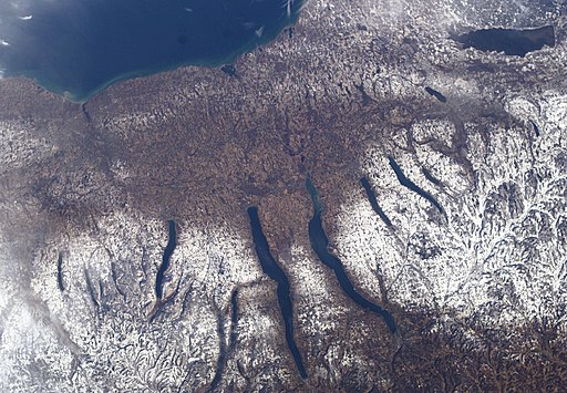
Case study: The Finger Lakes of North America
Shortly after 14,500 years ago, during the deglaciation of North America and the retreat of the Laurentide Ice Sheet, the 80 km wide Seneca-Cayuga paleo ice stream occupied the overdeepened New York State Finger Lake basins [9]. This ice stream formed mega-scale glacial lineations and other streamlined landforms.

The maps showed clear ice flow patters, with landforms representing faster flow (Mega Scale Glacial Lineations) to steady state flow (drumlins), and highlighted the role that the Finger Lakes had on the ice flow speed. Evidence also suggests that the fast ice flow resulted in the increase in erosion potential from abrasion and subglacial meltwater resulting in the continuous overdeepening of the Finger Lakes, causing them to have their deep, elongated structure [9].
Explore the Finger Lakes of New York in the interactive embedded Google Map below.
The Finger Lakes are around 200 m deep, and are cut into the Allegheny Plateau. They occupy narrow, steep-sided bedrock basins, extending up to 70 km into the plateau. The largest Finger Lakes radiate outward to the south, like fingers on an outstretched hand [9]. The bedrock floors of the largest lakes are over-deepened, to well below sea level (e.g. the Rochester Basin at – 244 m below mean sea level). This over deepening indicates that these lakes have been a locus for enhanced glacial erosion over multiple glacial cycles [9].
Drumlins and mega-scale glacial lineations are well aligned with the lakes, indicating the direction of ice flow.

We can use the orientation of these geomorphological features and the lakes, and the position of the moraines, to reconstruct the former ice-flow pathways of the Seneca-Cayuga paleo ice stream [9].

Further reading
Earth from Space: the Great Lakes
Dig the Dunes: glaciation and the formation of Lake Michigan
Open access images used were available under a Creative Commons License.