The following is a list of publically available Antarctic datasets. These datasets are often freely accessible, usually providing that you cite the source and often a relevant paper. Do not use data without correct attribution. Many of these datasets have been used in the creation of figures on this website, and I thank all the authors that have contributed their data. There are many more datasets around, but these ones concentrate on Antarctic Glaciers. I hope this list is useful.
Much of this data is aimed at academics rather than as outreach, and assumes users are familiar working with ASCII data or various other GIS formats such as GEOTIFFs. However, many of the Antarctic datasets listed may be interesting to teachers and educators as well as researchers.
Browse the datasets:
- BEDMAP2
- Antarctic BedMachine
- Ice velocity
- Grounding line data
- Landsat Image Mosaic of Antarctica
- MOA image map
- Antarctic Digital Database
- IBCSO Bathymetric data
- ASTER GDEM of the Antarctic Peninsula
- Global Land-Ice Measurements from Space (GLIMS)
- Marine Geoscience Data System
- DIVA-GIS country boundaries
- IPCC projections and data
- Further resources
BEDMAP2
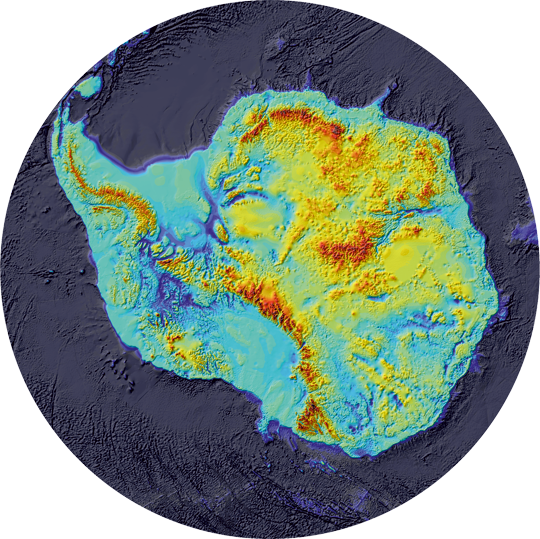
BEDMAP2 is a compilation of bedrock topography data from around the Antarctic continent. The dataset includes bed topography, ice surface elevation, a rock mask, ice shelf mask, ice thickness and more. Data are available as ASCII files, suitable for loading into a GIS.
Download the PDF from The Cryosphere.
Citation: Fretwell, L.O., H. D. Pritchard, D. G. Vaughan, J. L. Bamber, N. E. Barrand, R. Bell, C. Bianchi, R. G. Bingham, D. D. Blankenship, G. Casassa, G. Catania, D. Callens, H. Conway, A. J. Cook, H. F. J. Corr, D. Damaske, V. Damm, F. Ferraccioli, R. Forsberg, S. Fujita, P. Gogineni, J. A. Griggs, R. C. A. Hindmarsh, P. Holmlund, J. W. Holt, R. W. Jacobel, A. Jenkins, W. Jokat, T. Jordan, E. C. King, J. Kohler, W. Krabill, M. Riger-Kusk, K. A. Langley, G. Leitchenkov, C. Leuschen, B. P. Luyendyk, K. Matsuoka, Y. Nogi, O. A. Nost, S. V. Popov, E. Rignot, D. M. Rippin, A. Riviera, J. Roberts, N. Ross, M. J. Siegert, A. M. Smith, D. Steinhage, M. Studinger, B. Sun, B. K. Tinto, B. C. Welch, D. A. Young, C. Xiangbin & Zirizzotti, A., 2013. Bedmap2: improved ice bed, surface and thickness datasets for Antarctica. The Cryosphere 7, 375-393.
BedMachine
BedMachine is a self-consistent dataset of the bed topography of Antarctica (also for Greenland). It is freely available at the NSIDC.
BedMachine provides a NetCDF on a 450m resolution grid, and has a nominal date of 2012. It gives surface elevation, ice thickness and bed topography, and is an update of BedMap2.
There are some great visualisations of the data set here.

Citation:
Morlighem, M., Rignot, E., Binder, T. et al. Deep glacial troughs and stabilizing ridges unveiled beneath the margins of the Antarctic ice sheet. Nature Geoscience 13, 132–137 (2020)
Ice velocity

The Rignot et al 2011 dataset allows users to download ice velocity across the Antarctic continent. The digital ice motion map is available as a MEaSUREs Earth Science Data Record (ESDR) at the National Snow and Ice Data Centre, Boulder, CO.
Citation: Rignot, E., Mouginot, J. & Scheuchl, B., 2011. Ice Flow of the Antarctic Ice Sheet. Science 333, 1427-1430.
Grounding line data
Rignot et al. 2011 also have a Grounding Line dataset available for download. Download the Grounding Line Data.
Citation: Rignot, E., Mouginot, J. & Scheuchl, B., 2011. Antarctic grounding line mapping from differential satellite radar interferometry. Geophys. Res. Lett. 38, L10504.
Landsat Image Mosaic Antarctica (LIMA)

Download a beautiful Landsat image mosaic of Antarctica. This dataset was created in support of the International Polar Year (IPY 2007-2008) with a virtually cloudless, seamless, high resolution satellite view of Antarctica. It was created by the USGS, the British Antarctic Survey and NASA.
MOA (MODIS Mosaic of Antarctica) image map
The NSIDC and the University of New Hampshire have assembled a digital image map of Antarctica and surrounding islands. The MODIS Mosaic of Antarctica is 260 swaths of Terra and Aqua MODIS (Moderate Resolution Imaging Spectroradiometer) images acquired between 20th November 2003 and 29th February 2004.
To download the data, users will need to register.
Citation: Haran, T., J. Bohlander, T. Scambos, T. Painter, and M. Fahnestock compilers. 2005, updated 2006. MODIS mosaic of Antarctica (MOA) image map. Boulder, Colorado USA: National Snow and Ice Data Center. Digital media.
Scambos, T., T. Haran, M. Fahnestock, T. Painter, and J. Bohlander. 2007. MODIS-based Mosaic of Antarctica (MOA) data sets: continent-wide surface morphology and snow grain size. Remote Sensing of Environment 111(2): 242-257. 10.1016/j.rse.2006.12.020.
Antarctic Digital Database (ADD)

A whole host of resources are available through the ADD. The SCAR Antarctic Digital Database is managed by the British Antarctic Survey and the Scientific Committee for Antarctic Research. Users can use a map viewer to download multiple features across Antarctica in various formats. There is a combination of point (vector) and raster data.
Data includes: hillshade and bathymetry, LIMA mosaic, sea mask, BEDMAP2, coastlines, ice shelf margins, coastal change, contours, elevations, moraines, place names, lakes, streams, subglacial lakes, stations, and bases.
Go to the Map Viewer to access data. Users will need to register to access data.
IBCSO (International Bathymetric Chart of the Southern Ocean)

The IBCSO website provides information on sea floor topography. Users can download a PDF chart or Geotiff data of the entire ocean floor.
When using any data from the IBCSO project please cite:
Arndt, J.E., H. W. Schenke, M. Jakobsson, F. Nitsche, G. Buys, B. Goleby, M. Rebesco, F. Bohoyo, J.K. Hong, J. Black, R. Greku, G. Udintsev, F. Barrios, W. Reynoso-Peralta, T. Morishita, R. Wigley, “The International Bathymetric Chart of the Southern Ocean (IBCSO) Version 1.0 – A new bathymetric compilation covering circum-Antarctic waters”, Geophysical Research Letters, doi: 10.1002/grl.50413
ASTER GDEM of the Antarctic Peninsula

This dataset, created by Alison Cook, provides a 100 m resolution surface topography DEM of the Antarctic Peninsula. Data are available via FT in GeoTIFF and ASCII formats.
Download the Data. Users must register to download the data.
Citation: Cook, A. J., T. Murray, A. Luckman, D. G. Vaughan, and N. E. Barrand. 2012. Antarctic Peninsula 100 m Digital Elevation Model Derived from ASTER GDEM. [indicate subset used]. Boulder, Colorado USA: National Snow and Ice Data Center. http://dx.doi.org/10.7265/N58K7711.
Global Land-Ice Measurements from Space (GLIMS)
The GLIMS dataset provides platform-independent GIS shapefiles of glaciers worldwide, including some from the Antarctic Peninsula. Users can browse glacier outlines using the GLIMS viewer, and download relevant glacier shapefiles. Users should cite the author of the shapefile as well as the GLIMS database.
Marine Geoscience Data System (MGDS)
The MGDS provides access to data portals for the NSF. These portals provide free public access to a wide variety of marine geoscience data collected during expeditions across the World’s oceans. Users can explore data using the GeoMapApp. Data available through the Antarctic and Southern Ocean Data Portal include seafloor bathymetry, subbottom profiling, trackline gravity and magnetics, meterological and water column data.
DIVA-GIS
The DIVA-GIS website provides free GIS data for any country in the world, including country boundaries, inland water, roads, railways, population and more.
IPCC data
The IPCC Data Distribution Centre (DDC) for the International Panel on Climate Change (IPCC) provides climatic, socio-economic and environmental data, from the past and also for projections into the future.
Further resources
The NSIDC has a list here of available Antarctica datasets, including:
- Antarctic 5 km DEM
- GEOSAT Radar Altimeter DEM Atlas of Antarctica
- ICESat 500m Laser Altimetry DEM of Antarctica
- Ice Thickness and Surface Elevation, Southeastern Ross Embayment
- MODIS MOA image map
- Radarsat Antarctic Mapping Project DEM V2.
The NSIDC has a great list of easy to use resources that are suitable for K-12 teachers and students, the press, the general public and non-cryospheric researchers. Datasets include:
- MASIE measurements of daily sea ice extent
- Sea ice index
- Frozen ground maps
- Glacier photographs
- Atlas of the Cryosphere
Google Earth has fabulous satellite images of Antarctica, and it lets you explore the continent from the comfort of your sofa.
If you know of any more datasets, please add a comment in the box below!
Go to top.
This website is GREAT! The information provided is useful and interesting. Talking to a scientist is such a helpful way of getting the best advice from the people who know this stuff the best. I will definitely recommend this to friends. 🙂
Many thanks, and glad you enjoyed the website!
Very informative website. Really helpful. Just wanted to tell everyone about a new GIS package Quantarctica from the Norwegian Polar Institute. It is a great free source of all the basic, satellite, geophysical, glacioligical and other data relating Antarctica.
http://www.quantarctica.org
All the best!
Vikram, thanks for pointing out this useful resource!
Thank you very for sharing! I really did find what I need for a mapping project:)
nice…..but not so clear
Woah! Thanks buddy!
This website is soooo great for a new beginner of Antarctica!