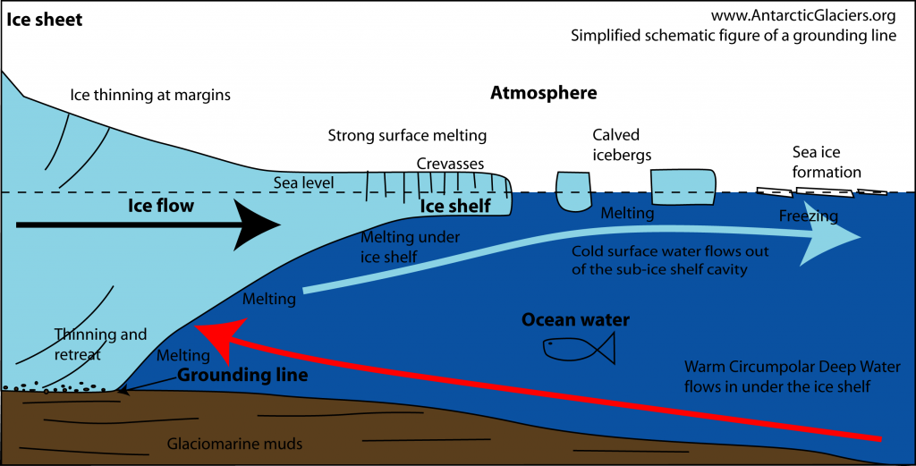
What is a grounding line?
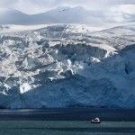
Almost all of Antarctica is covered in ice. Less than 1% its land area is ice free. This means that, across Antarctica, almost all glaciers end in the ocean, whereupon they calve icebergs. These glaciers can be grounded, or can end in floating ice tongues or larger ice shelves. These floating ice shelves move with the tide. Ice shelves fringe 75% of Antarctica’s coastline, while collecting 20% of its snowfall over 11% of its area[1]. Basal melt from ice shelves is the largest melting process in Antarctica. Clearly, ice sheet – ocean interactions are extremely important for controlling ice sheet dynamics and rates of melting and recession.

Glaciers that end in the ocean like this are called Tidewater Glaciers. They may be grounded (the glacier is in contact with the bed entirely), or parts of the glacier terminus may be floating. Glaciers that flow into an ice shelf are tributary glaciers.
The point at which glaciers and ice shelves start to float is the Grounding Line. The location of the grounding line is important, because mass loss from Antarctica is strongly linked to changes in the ice shelves and their grounding lines[2, 3]. Change in the grounding line can result in very rapid changes in glacier and ice-shelf behaviour (for example, see Marine ice sheet instability).


The transition from grounded ice sheet to floating ice shelf plays an important role in controlling marine ice sheet dynamics, as it determines the rate at which ice flows out of the grounded part of the ice sheet[4]. This is because ice flux through the grounding line increases sharply with ice thickness at the grounding line. This means that grounding lines are unstable on reverse-bed slopes, such as those under Pine Island Glacier, because recession into deeper water increases ice flux and further encourages more glacier recession.

 Mapping the grounding line

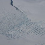
Grounding lines are actually more of a zone. The grounding zone is the region where ice transitions from grounded ice sheet to freely floating ice shelf, typically over several kilometres. The floating ice shelf changes in elevation in response to tides, atmospheric air pressure and oceanic processes. Grounding occurs when the ice shelf comes into contact with the bedrock below.
The grounding zone is the region between point F on the figure below, where there is no tidal movement, and point H, which is the seaward limit of ice flexure, where the ice is free-floating.

The grounding zone can be difficult to detect; it may take place over a wide area[5], and area can be remote and inaccessible and so difficult to monitor. Fortunately, there is a subtle feature that can be observed on satellite images. There is often an elevation minimum between points G and H (Point Im in the cartoon above). Elevation profiles across the grounding line will often show a break in slope (Point Ib).
Other methods for detecting the grounding line rely on measuring changes in surface elevation during the tidal cycle, which can be measured by GPS or satellite synthetic aperture radar (eg., InSAR) or ICESat[2, 5, 6].

Current grounding line change
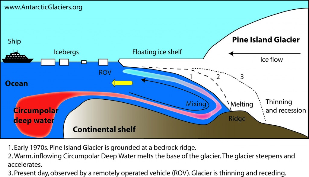
Across the Antarctic Peninsula and West Antarctica, increased upwelling of the relatively warm Circumpolar Deep Water is melting ice at the grounding line. In the Amundsen Sea, this has resulted in glacier acceleration, thinning, and grounding line recession. Circumpolar Deep Water, which is a key component of the Antarctic Circumpolar Current, is able to reach the undersides of the ice shelves and the grounding line by flowing through deep submarine troughs[7]. This has resulted in rapid grounding-line recession at Pine Island Glacier[8] – up to 31 km from 1992 to 2011.
Recognising grounding lines from the past
Grounding lines leave behind a distinct geomorphological and sedimentological record[9-14] on the continental shelf that scientists can use to map and date former grounding line positions. This crucial information can be used to reconstruct past ice-sheet extent; e,.g., [15, 16].
Grounding zone wedges form transverse to ice flow and can be mapped by ships equipped with swath bathymetry, which allows them to create a detailed topographical map of the sea floor[17]. These grounding zone wedges represent either past maximum ice-sheet extent, or recessional positions during deglaciation.
Grounding zone wedges (also known as ‘till deltas’ or ‘ice-contact submarine fan’[9]) build up under stable ice margins; they require the grounding line to remain in a stable position for long enough for enough sediment to accumulate to build a wedge or ridge[17]. Grounding zone wedges are sedimentary depocentres that form at the transition from grounded to floating ice. They typically consist of well-bedded foreset and bottomset deposits.
I haven’t seen any mention of the “water lift” effect (like an air lift). As the under surface of the ice melts, it freshens the sea water adjacent to the ice. This water is lighter than full sea water and will flow upward along the sloping ice ceiling. The circumpolar water is not intruding into the space between the ice and the sea bottom. It is being sucked in. The fresher water flows out on the surface and is more easily frozen than full strength sea water which may possibly contribute to the increased sea ice around Antarctica. A second, possibly minor effect is that the melting temperature of ice is lower at high pressure. Water flowing up the sloping ice ceiling may be super cooled in relation to the shallower depths it flows into. This could further encourage the formation of sea ice. As the grounding line gets deeper and deeper on the reverse slope as the ice melts back landward, not only is the melting point of ice lower and lower but the water lift effect should increase just as an air lift does when you lower the intake into deeper and deeper water.
Regards
William
I wonder if the tidal pump is significant. As the floating ice rises with the tide, the volume of the cavity below the ice increases. In other words, water is sucked in under the ice. As the tide drops the ice, the volume decreases. Water is expelled from under the ice. As the grounding line retreats, the cavity increases in volume. The water exchange each tidal cycle increases. Could this be increasing the retreat of the grounding line.
Some grounding line plume calculations (Antarctica 2.0 – 11).