
By Dr Alex Clark
Why Ireland?
Ice sheets provide valuable clues on how they behaved thousands of years in the past through the dramatic landscapes they create. And you may struggle to find a more elaborate signature than on the island of Ireland, scribbled out by the last British-Irish Ice Sheet approximately 30,000 to 15,000 years ago.
This is in part due to the island’s complex ice sheet history. Moraines, meltwater channels, deltas, drumlins all tell a unique story of how the ice sheet transitioned to a relatively small, land-based ice mass after its rapid retreat from the ocean 1–5.
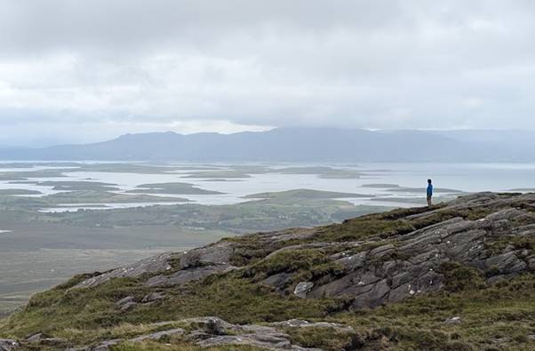
But the history of this transitional period is not well understood. How did the ice sheet behave after taking its toes out of the sea? What were the main drivers of decay on a smaller ice sheet? Over what time scales did the ice sheet disappear? These questions are important to address as they could inform us of how analogous contemporary ice sheets may undergo similar styles of deglaciation in the future.
Our new paper in Geomorphology 6 aims to explore the behaviour of ice sheet decay in northeast Ireland with the aim of addressing some of these questions.
A Birds Eye View
To understand palaeo-ice sheet dynamics at a broad scale, we first had to map the landforms left behind by the ice sheet.
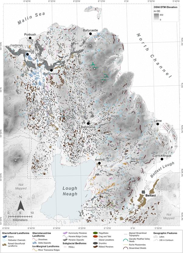
We achieved this by identifying and mapping these features on a digital surface model derived from aerial orthophotos of Northern Ireland. Each pixel of this model represents just a 40 x 40 cm area (the size of a throw pillow), and there are 2.4 million of them covering our 3,905 km2 study area. This allowed us to pick out the most subtle (metres in length) to the most dramatic (kilometres in length) glacial landforms.
To our knowledge, ours is the first study in the British and Irish Isles to use such a high-resolution digital surface model over such a large continuous area to map glacial landforms. The result is 12,979 individual glacial features, which you can download and play with yourself or view in the map below.
Varied glacial landforms
We found that the suite of glacial landforms preserved in the region is quite varied. Additionally, some landforms were mapped for the very first time on the island of Ireland. For example, very subtle corrugated ridges, called ‘minor transverse ridges’, tell us about how actively retreating ice margins shunted and crumpled large volumes of sediment 7. Narrow, straight, 700 m-long mounds, called ‘megaflutes’, reveal that the ice was often flowing faster than an ordinary glacier, possibly due to increased melting at the bed 8,9.
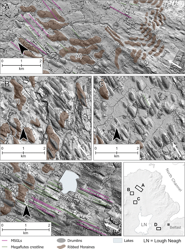
Sometimes landforms are superimposed on each other or show different degrees of ‘evolution’, recording transitions in the behaviour of the overlying ice. The most striking examples of this are megaflute- and drumlin-superimposed ribbed moraines found on the gentle slopes of the Lower Bann valley. These features are known to form at the margin of very fast-flowing glaciers (ice streams) due to the immense, variable stresses at their margins 10. This is an exciting find in Northern Ireland, as it provides some brand-new insights into the dynamic nature of deglaciation.
How Did That Boulder Get There?
Mapping glacial landforms on a computer screen is a valuable exercise and, to some like me, quite therapeutic. However, going out into the field and examining the make-up of those landforms can tell us more about how they formed.
Part of our research involved doing just this. As we explored Co. Antrim, we encountered exposures of glacial sediments – some that had never been studied before, and some that received some attention in the past but could have benefited from more detailed analysis.
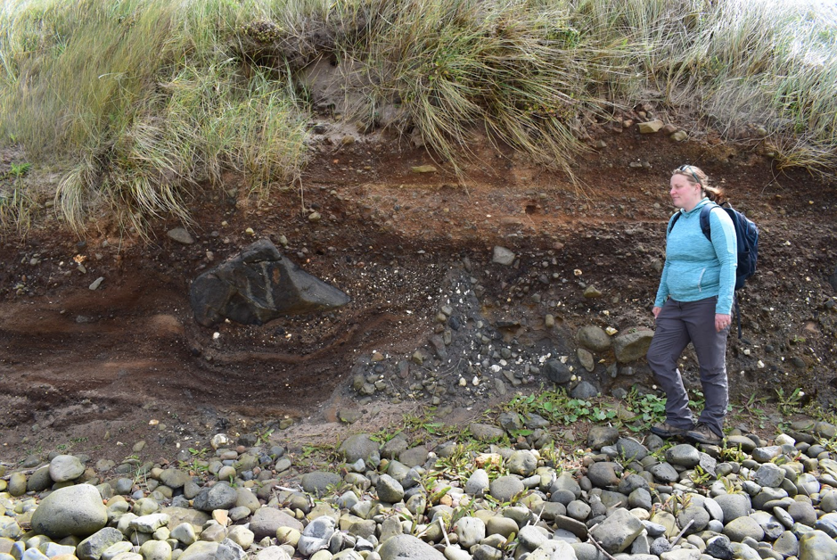
The Quaternary Research Association kindly provided funding to undertake this field exploration through the New Research Workers Award. Below you can see Bethan very pleased with a fantastic section of gravels, cobbles, and an impressive boulder. This particular section provided insights into the ejection of material from the ice margin into a subaqueous environment (either a lake or the sea).
Combining our geomorphological and sedimentological results provides us with better understand the processes behind landform formation. Grouping landforms and sediments based on their common formation mechanisms further allows us to reconstruct changes in the behaviour of the ice sheet.
Painting A Picture
After collating and interpreting all this evidence, we can begin to unravel the nature of deglaciation in northeast Ireland.
Kleman and Borgström (1996) 11 fleshed out the concept that glacial landforms and sediments are ‘metachronous’. That is, they were not formed during a single event, but rather over a period of time, even though they occupy the same space in the present day. They are like a painting, where the brush was smeared over the canvas one stroke after the other to produce a single, still image. This concept allows us to reconstruct what an ice sheet was doing through time.
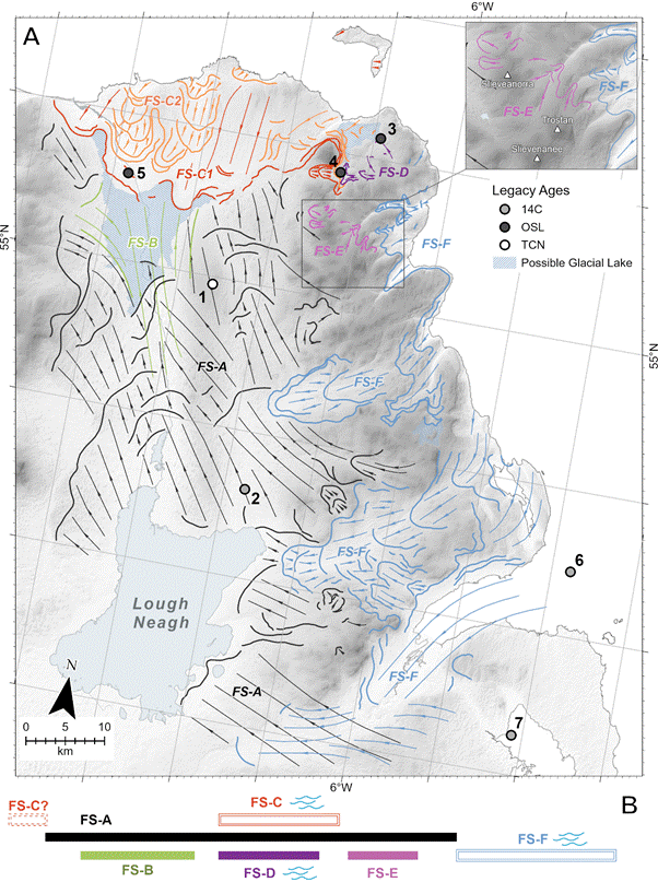
The map below is our way of figuring out which brush strokes were made where and in what order. The strokes (glacier flowlines) are grouped by how similar they look and whether their associated glacial sediments point to similar processes underway at the time.
Complex deglaciation
Building on findings from previous research 12–14, we show that deglaciation over this region was complex and involved multiple different ‘stages’. Ice sheet thinning played a more important role than initially thought throughout the decay of the main Lough Neagh ice centre (Flow Stage A).
As it thinned and wasted, a small ice stream briefly flowed through the Lower Bann valley (Flow Stage B) before switching off. The readvance of a huge ice stream margin (Flow Stage C) shaped the landform signature of the north coast of Co. Antrim, providing further insights into ice stream behaviour.
Smaller ice masses also played a role in shaping the landscape (Flow Stages D and E), telling us about how small, sensitive icefields decayed next to the larger ice sheet.
Finally, an ice centre over northeast Ireland collapsed, but ice originating from Scotland extended along the east coast of the island (Flow Stage F). This growing influence of Scottish ice whilst Irish ice disappears tells us about some interesting palaeo-ice sheet dynamics we discuss in the paper.
Further Reading
- Glacial geomorphological mapping
- The Irish Ice Sheet
- Alpine icefield landsystem of northern Britain
- Plateau icefield landsystem of upland Britain
- The Last Glacial Maximum
- Shelf-edge moraines of the British-Irish Ice Sheet
About the Author: Alex Clark
I am a postdoctoral researcher in the Palaeoenvironmental Research Unit at the University of Galway, Ireland. I currently investigate palaeoclimate proxies and all things related to reconstructing glacier retreat in the past, with a particular interest in how seasonality played a role in deglaciation. My background in palaeoglaciology, geomorphology, geochronological methods, and sedimentology, allows me to investigate the timing and nature of glacier response during high-magnitude climate changes. I hope to incorporate these specialties and new skills into future research projects in Ireland and internationally.