Following the Last Glacial Maximum (LGM), global climate began to warm from around 19,000 years ago, marking the onset of widespread deglaciation across the Northern Hemisphere1. As temperatures increased, the Laurentide Ice Sheet began to thin and retreat from its maximum extent. The balance between snowfall and melting shifted, and ice margins progressively withdrew northward2. Deglaciation was not a single, continuous process but unfolded over several millennia, extending into the early Holocene, the interglacial period that began ~11.700 years ago and continues to the present3.
Figure 1. Time-slice reconstruction showing retreat of the Laurentide Ice Sheet following the Last Glacial Maximum. Time is shown in ka (thousand years ago). Credit: TKostolany, 20144. Source: Wikimedia Commons.
Pattern of ice retreat
The retreat of the Laurentide Ice Sheet occurred in distinct phases linked to major climate events. An early phase of rapid ice loss followed Heinrich Event 1, around 17,500-16,000 years ago, when massive discharges of icebergs and meltwater entered the North Atlantic and disrupted ocean conditions5,6. Subsequent warming during the Bølling–Allerød interstadial (around 14,700–12,900 years ago) accelerated ice retreat across much of North America7.
Ice margins did not retreat uniformly across the continent. In some regions, retreat was rapid and sustained, while in others the ice margin stabilized or even temporarily re-advanced2. Large proglacial lakes formed along the southern and western margins as meltwater became trapped between the retreating ice and higher ground. Over time, the ice sheet separated into smaller sectors as its interior thinned and divides shifted northward.
The Younger Dryas
Around 12,900 years ago, a return to colder conditions interrupted the overall warming trend. This period, known as the Younger Dryas, lasted for roughly 1,200 years and is clearly recorded in ice cores, marine sediments, and terrestrial records across the Northern Hemisphere8.
The Younger Dryas is characterized by a rapid drop in temperatures, particularly in the North Atlantic region. One leading hypothesis links this cooling to changes in ocean circulation triggered by large freshwater inputs from proglacial lakes associated with the retreating Laurentide Ice Sheet9. Other proposed mechanisms, including large meteorite impacts or changes in atmospheric circulation, remain debated10, and the exact combination of drivers is still being studied.
During the Younger Dryas, some parts of the Laurentide Ice Sheet stabilized or experienced glacier re-advances, while overall deglaciation slowed, reflecting the sensitivity of ice margins to abrupt climate changes2.
Figure 2. Reconstructed air temperatures from the GISP2 ice core in Greenland, showing major climate transitions during deglaciation. Rapid warming during the Bølling–Allerød interstadial was followed by abrupt cooling during the Younger Dryas, before temperatures rose again into the relatively stable Holocene interglacial. Credit: Platt et al., 201711
Impacts of deglaciation
As the Laurentide Ice Sheet retreated, vast quantities of meltwater were released. This meltwater was routed through changing drainage networks, sometimes flowing southward through the Mississippi basin and at other times eastward into the North Atlantic. Large proglacial lakes, including Lake Agassiz, repeatedly reorganized and drained, altering freshwater delivery to the oceans and strongly influencing ocean circulation and climate12.
Deglaciation also reshaped migration pathways into the Americas. As ice retreated from western Canada, potential migration routes opened between the Laurentide and Cordilleran ice sheets, while lower sea levels earlier had exposed the Bering Land Bridge between Asia and North America13.
The timing and accessibility of these routes were closely tied to the configuration and retreat of the ice sheets and strongly influenced how and when people colonized large parts of the Americas.
Figure 3. Reconstruction of migration routes into the Americas. Early human populations entered via the Bering Land Bridge and later migrated southward along coastal routes and through interior ice-free corridors that opened during deglaciation Credit: Kitchen et al., 200814.
Final disappearance of the Laurentide Ice Sheet
After the Younger Dryas ended, rapid warming at the start of the Holocene (~ 11.700 years ago) led to renewed and sustained ice retreat15. Over the next several millennia, the Laurentide Ice Sheet fragmented into smaller ice caps and ice fields before disappearing entirely from mainland North America2.
As the ice sheet melted, global sea level rose rapidly, reshaping coastlines worldwide16. At the same time, removal of the immense weight of ice allowed the Earth’s crust, which had been depressed under the load, to rebound upward in a process known as glacial isostatic adjustment, a response that continues in parts of Canada today17.
By the mid-Holocene, the main Laurentide Ice Sheet had vanished, marking the end of a major phase of North American glaciation and leaving behind a landscape and drainage network profoundly shaped by its advance and retreat.
Figure 4. Isostatic adjustment. (A) Present-day global vertical land motion in mm per year. Due to glacial isostatic adjustment land continues to rise in regions formerly covered by the Laurentide Ice Sheet, particularly around its center by Hudson Bay, while peripheral forebulge regions are subsiding. Credit: Ivins, 201018. Source: Wikimedia Commons. (B) Schematic illustration of glacial isostatic adjustment. The Earth’s crust is depressed beneath large ice sheets and rebounds after melting, while regions beyond the former ice margin subside as mantle material redistributes. Credit: U.S. Geological Survey, 202219
Interactive Webmap
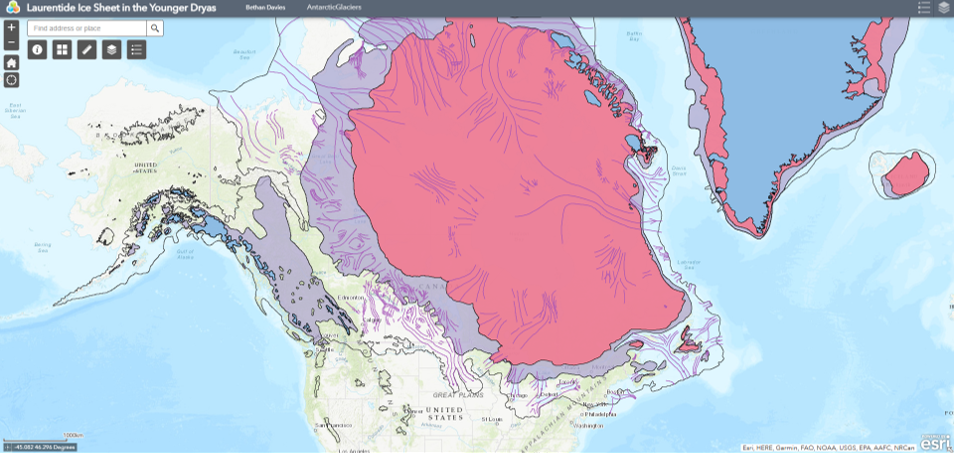
Explore the deglaciation of the Laurentide Ice Sheet in this webmap.
Explore the deglaciation of the Laurentide Ice Sheet in this interactive webmap, using shapefiles provided by Dalton et al., 2023.
Clark, P. U., Dyke, A. S., Shakun, J. D., Carlson, A. E., Clark, J., Wohlfarth, B., … & McCabe, A. M. (2009). The last glacial maximum. Science, 325(5941), 710-714.
Dyke, A. S. (2004). An outline of North American deglaciation with emphasis on central and northern Canada. Developments in Quaternary Sciences, 2, 373-424.
Walker, M., Head, M. J., Berkelhammer, M., Björck, S., Cheng, H., Cwynar, L., … & Weiss, H. (2018). Formal ratification of the subdivision of the Holocene Series/Epoch (Quaternary System/Period): two new Global Boundary Stratotype Sections and Points (GSSPs) and three new stages/subseries. Episodes, 41(4), 213-223.
Heinrich, H. (1988). Origin and consequences of cyclic ice rafting in the northeast Atlantic Ocean during the past 130,000 years. Quaternary Research, 29(2), 142-152.
Hemming, S. R. (2004). Heinrich events: Massive late Pleistocene detritus layers of the North Atlantic and their global climate imprint. Reviews of Geophysics, 42(1).
Dansgaard, W., Johnsen, S. J., Clausen, H. B., Dahl-Jensen, D., Gundestrup, N. S., Hammer, C. U., … & Bond, G. (1993). Evidence for general instability of past climate from a 250-kyr ice-core record. Nature, 364(6434), 218-220.
Alley, R. B. (2000). The Younger Dryas cold interval as viewed from central Greenland. Quaternary Science Reviews, 19(1-5), 213-226.
Broecker, W. S., Kennett, J. P., Flower, B. P., Teller, J. T., Trumbore, S., Bonani, G., & Wolfli, W. (1989). Routing of meltwater from the Laurentide Ice Sheet during the Younger Dryas cold episode. Nature, 341(6240), 318-321.
Broecker, W. S., Denton, G. H., Edwards, R. L., Cheng, H., Alley, R. B., & Putnam, A. E. (2010). Putting the Younger Dryas cold event into context. Quaternary Science Reviews, 29(9-10), 1078-1081.
Platt, D. E., Haber, M., Dagher-Kharrat, M., Douaihy, B., Khazen, G., Ashrafian Bonab, M., Salloum, A., Mouzaya, F., Luiselli, D., Tyler-Smith, C., Renfrew, C., Matisoo-Smith, E., & Zalloua, P. A. (2017). Mapping Post-Glacial expansions: The Peopling of Southwest Asia. Scientific Reports, 7, 40338. https://www.nature.com/articles/srep40338
Clarke, G. K., Bush, A. B., & Bush, J. W. (2009). Freshwater discharge, sediment transport, and modeled climate impacts of the final drainage of glacial Lake Agassiz. Journal of Climate, 22(8), 2161-2180.
Goebel, T., Waters, M. R., & O’Rourke, D. H. (2008). The late Pleistocene dispersal of modern humans in the Americas. Science, 319(5869), 1497-1502.
Walker, M., Johnsen, S., Rasmussen, S. O., Popp, T., Steffensen, J. P., Gibbard, P., … & Schwander, J. (2009). Formal definition and dating of the GSSP for the base of the Holocene using the Greenland NGRIP ice core, and selected auxiliary records. Journal of Quaternary Science, 24(1), 3-17.
Lambeck, K., Rouby, H., Purcell, A., Sun, Y., & Sambridge, M. (2014). Sea level and global ice volumes from the Last Glacial Maximum to the Holocene. Proceedings of the National Academy of Sciences, 111(43), 15296-15303.
Peltier, W. R. (2004). Global glacial isostasy and the surface of the ice-age Earth: the ICE-5G (VM2) model and GRACE. Annual Review of Earth and Planetary Sciences, 32(1), 111-149.