Introduction: timescale and climate setting at the Last Glacial Maximum
The Last Glacial Maximum (LGM) marks the coldest interval of the most recent glacial period, occurring between approximately 26,000 and 20,000 years ago. During this time, global temperatures were substantially lower than today, and large ice sheets reached their maximum extent across the Northern Hemisphere1. In North America, these cold conditions allowed the Laurentide Ice Sheet to grow to its greatest size2.
The climate at the LGM was also drier than today, with a generally weakened global hydrological cycle3. Reduced atmospheric moisture limited snowfall in many regions, but persistently low temperatures meant that snow accumulated over long periods with little summer melting. This combination of cold temperatures and low ablation created conditions favourable for the long-term persistence of vast continental ice sheets4.
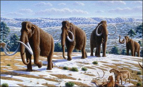
Figure 1. Artist’s illustration of woolly mammoths (Mammuthus primigenius) and other cold-adapted megafauna inhabiting a cold, open steppe-tundra environment typical of regions bordering the Laurentide Ice Sheet during the Last Glacial Maximum. Such environments were widespread across unglaciated parts of North America under colder and drier climatic conditions. Credit: Mauricio Antón, 2004. Source: Wikimedia Commons.
Extent and thickness of the Laurentide Ice Sheet
At the LGM, the Laurentide Ice Sheet covered most of present-day Canada and extended south into the northern United States. Its southern margin reached as far as the Great Lakes region and parts of the Midwest and north-eastern United States, while to the west and north it was bounded by the Cordilleran and Innuitian ice sheets, making it one of the largest continental ice sheets of the Quaternary and the largest during the LGM outside of Antarctica1.
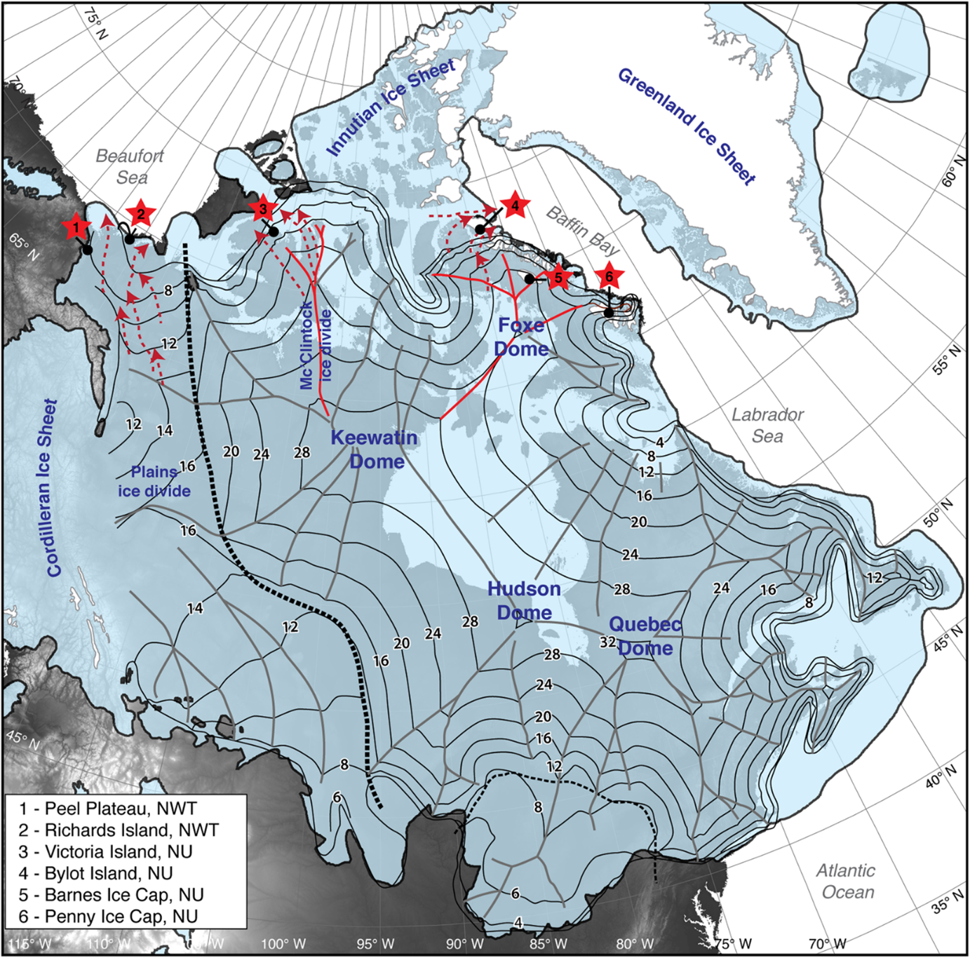
The ice sheet was thickest over central Canada, particularly over the Hudson Bay region and adjacent shield, where ice thickness is estimated to have reached on the order of 3-4 km6. However, the Laurentide Ice Sheet was not a single, uniform mass of ice. Instead, it consisted of several major ice domes separated by broad ice divides, primarily the Keewatin, Foxe, Hudson, and Quebec domes.
Figure 2. Maximum extent of the Laurentide Ice Sheet during the Last Glacial Maximum, covering most of Canada and extending into the northern United States. The ice sheet was bounded to the west by the Cordilleran Ice Sheet and to the north by the Innuitian and Greenland ice sheets. Credit: Lacelle et al., 20187.
Interactive Webmap
Explore the Laurentide Ice Sheet at the LGM in this webmap.
Ice-sheet dynamics
Ice within the Laurentide Ice Sheet flowed under its own weight from the thick interior toward its lowland peripheries, including the Great Plains, Mississippi basin, and Atlantic and Arctic coastal margins.
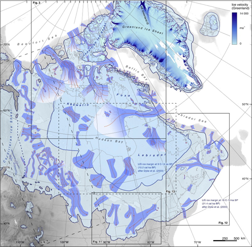
In several regions, ice discharge was concentrated into fast-flowing corridors known as ice streams8. These ice streams transported large volumes of ice and sediment toward peripheral basins and continental shelves and played a key role in regulating the overall behaviour and stability of the ice sheet9. In contrast, areas between ice streams were characterized by slower-moving ice that contributed less to total ice discharge.
Basal conditions strongly influenced these flow patterns. Where ice rested on soft, water-saturated sediments, it was able to slide more easily over its bed, promoting faster flow and the development of ice streams. In contrast, ice frozen to hard bedrock tended to move more slowly10. Spatial variations in basal temperature, bed material, and meltwater availability therefore exerted an important control on the dynamics of the Laurentide Ice Sheet at the LGM.
Figure 4. Ice streams of the Laurentide Ice Sheet during the Last Glacial Maximum (outer margin) and 10.200 years ago (inner margin), showing the major corridors of fast ice flow. Credit: Margold et al., 201511.
Global significance
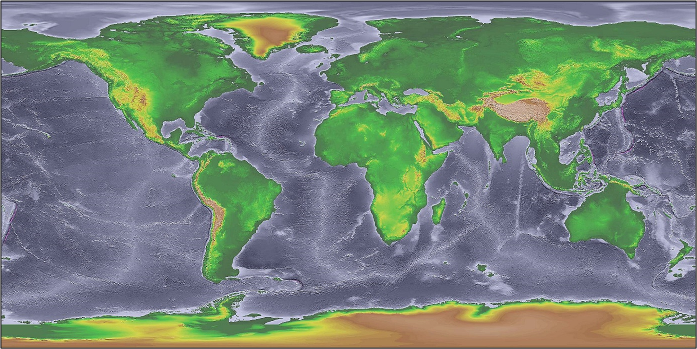
The Laurentide Ice Sheet stored a vast volume of water on land during the LGM, contributing significantly to global sea-level lowering1. At this time, global mean sea level is estimated to have been roughly 120-130 meters lower than today, exposing large areas of the continental shelves12. This led to the formation of land bridges, most notably Beringia between northeastern Asia and northwestern North America, which enabled the migration of plants, animals, and early human populations between continents13.
Beyond its influence on sea level, the Laurentide Ice Sheet affected climate well beyond North America. Its size and elevation altered atmospheric circulation patterns, contributing to cooler and drier conditions across large parts of the Northern Hemisphere14. As such, the Laurentide Ice Sheet played an important role in the global climate system during the LGM, with impacts that extended far beyond the regions it directly covered.
Figure 5. Global land surface during the Last Glacial Maximum, when sea level was approximately 120-130 m lower than today. Exposed continental shelves formed land bridges such as Beringia between Asia and North America. Credit: National Oceanic and Atmospheric Administration, 200815. Source: Wikimedia Commons.
Clark, P. U., Dyke, A. S., Shakun, J. D., Carlson, A. E., Clark, J., Wohlfarth, B., Mitrovica, J. X., Hostetler, S. W., & McCabe, A. M. (2009). The last glacial maximum. Science, 325(5941), 710–714.
Dyke, A. S. (2004). An outline of North American deglaciation with emphasis on central and northern Canada. Developments in Quaternary Sciences, 2, 373–424.
Tierney, J. E., Zhu, J., King, J., Malevich, S. B., Hakim, G. J., & Poulsen, C. J. (2020). Glacial cooling and climate sensitivity revisited. Nature, 584(7822), 569–573.
Imbrie, J., & Imbrie, J. Z. (1980). Modeling the climatic response to orbital variations. Science, 207(4434), 943–953.
Peltier, W. R. (2004). Global glacial isostasy and the surface of the ice-age Earth: the ICE-5G (VM2) model and GRACE. Annual Review of Earth and Planetary Sciences, 32(1), 111–149.
Lacelle, D., Fisher, D. A., Coulombe, S., Fortier, D., & Frappier, R. (2018). Buried remnants of the Laurentide Ice Sheet and connections to its surface elevation. Scientific Reports, 8(1), 13286. https://www.nature.com/articles/s41598-018-31166-2
Stokes, C. R., & Clark, C. D. (2001). Palaeo-ice streams. Quaternary Science Reviews, 20(13), 1437–1457.
Stokes, C. R., Margold, M., Clark, C. D., & Tarasov, L. (2016). Ice stream activity scaled to ice sheet volume during Laurentide Ice Sheet deglaciation. Nature, 530(7590), 322–326.
Boulton, G. S., & Clark, C. D. (1990). A highly mobile Laurentide ice sheet revealed by satellite images of glacial lineations. Nature, 346(6287), 813–817.
Lambeck, K., Rouby, H., Purcell, A., Sun, Y., & Sambridge, M. (2014). Sea level and global ice volumes from the Last Glacial Maximum to the Holocene. Proceedings of the National Academy of Sciences, 111(43), 15296–15303.
Hopkins, D. M. (1967). The Bering land bridge (Vol. 3). Stanford University Press.
Kageyama, M., Albani, S., Braconnot, P., Harrison, S. P., Hopcroft, P. O., Ivanovic, R. F., Lambert, F., Marti, O., Peltier, W. R., Peterschmitt, J. Y., Roche, D. M., Schmidt, G. A., Tarasov, L., Valdes, P. J., Zhang, Q., & Zheng, W. (2017). The PMIP4 contribution to CMIP6 – Part 4: Scientific objectives and experimental design of the PMIP4-CMIP6 Last Glacial Maximum experiments and PMIP4 sensitivity experiments. Geoscientific Model Development, 10(11), 4035–4055.
_-_Mauricio_Ant%C3%B3n.jpg)
