The Laurentide Ice Sheet no longer exists, but its imprint remains visible across large parts of North America. The study of these landforms – known as glacial geomorphology – allows scientists to reconstruct how the ice sheet behaved, where it flowed, and how it advanced and retreated1,2.
Different landforms form under different glacial conditions. Some develop at the ice margin, others beneath fast-flowing ice, and others through the action of meltwater. By mapping and interpreting these features, it is possible to piece together the former structure and dynamics of the Laurentide Ice Sheet3,4.
Ice-marginal landforms of the Laurentide Ice Sheet
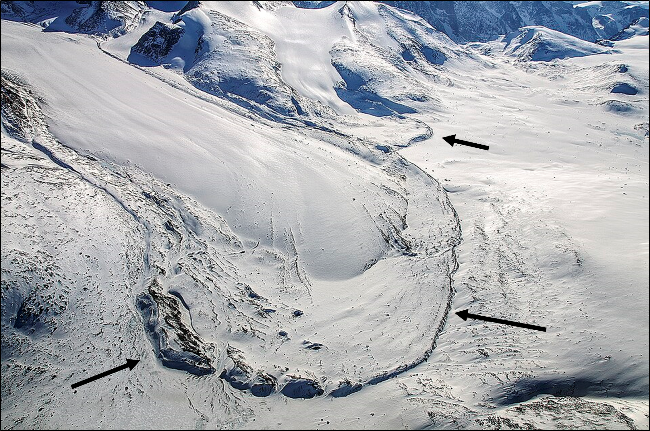
Ice-marginal landforms mark former positions of the ice edge and provide direct evidence of advance and retreat. The most prominent of these are moraines, which are ridges of sediment deposited at the margin of a glacier1. Large moraine belts across Canada and the northern United States record pauses or re-advances during overall retreat5.
Figure 1. Terminal (end) moraine of the Penny Ice Cap, Baffin Island, Canada. Moraines form at glacier margins where sediment accumulates, marking current or former ice limits. Credit: Michael Studinger, 20136. Source: Wikimedia Commons.
Other characteristic ice-marginal features include kames and kame terraces, which form where sediment is deposited in or against wasting ice, and kettle holes, which develop when buried ice blocks melt out to leave depressions in the land surface1.
Together, these landforms indicate zones where the ice margin was stagnant or downwasting rather than actively advancing and allow reconstruction of former ice-front positions and patterns of retreat through time.
Figure 2. Frozen kettle lakes within a moraine landscape at James Ross Island, Antarctica. Credit: Bethan Davies, 2014.
Subglacial landforms of the Laurentide Ice Sheet
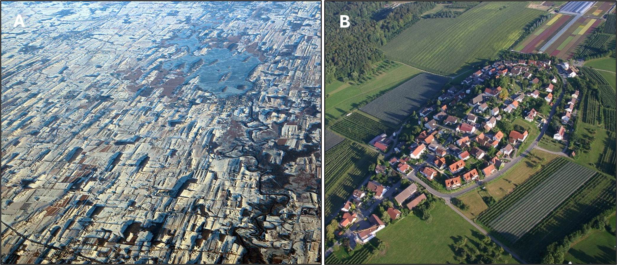
Beneath the Laurentide Ice Sheet, moving ice reshaped the underlying substrate. One of the most widespread subglacial landforms is the drumlin – an elongated hill streamlined in the direction of ice flow3. Drumlins often occur in large fields, providing clear indicators of past ice-flow direction.
Figure 3. Drumlins. (A) Extensive drumlin field near Horicon Marsh, Wisconsin, USA. Credits: Doc Searls, 20167. Source: Wikimedia Commons. (B) Individual drumlin in Germany with settlement built on its crest. These streamlined landforms indicate past ice-flow direction beneath the Laurentide Ice Sheet. Credit: Martin Groll, 20098. Source: Wikimedia Commons.
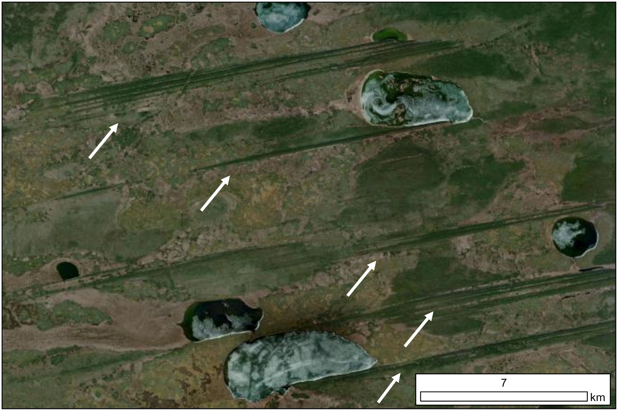
In areas of particularly fast flow, the bed was moulded into highly elongated features known as mega-scale glacial lineations (MSGLs). These landforms are typically associated with former ice streams and indicate zones of rapid ice movement over soft sediment3,9.
Figure 4. Mega-scale glacial lineations formed beneath fast-flowing ice streams. Credit: Google Earth, modified by Jakob Hamann, 2026.
In contrast, areas beneath colder or more slowly moving ice may contain ribbed moraines, consisting of transverse ridges that reflect different basal thermal and mechanical conditions10. The distribution of these subglacial landforms across North America reveals spatial variations in ice velocity, basal temperature, and substrate type within the Laurentide Ice Sheet.
Figure 5. Ribbed moraine landscape formed beneath slow-moving or cold-based ice. Credit: Jacob Bendle, 2019.
Meltwater landforms of the Laurentide Ice Sheet
Meltwater played a major role in shaping the landscape during both ice advance and retreat. Networks of large meltwater channels were carved into bedrock and sediment, sometimes cutting across present-day drainage divides. These channels record episodes of intense meltwater discharge and routing beneath former ice margins11.
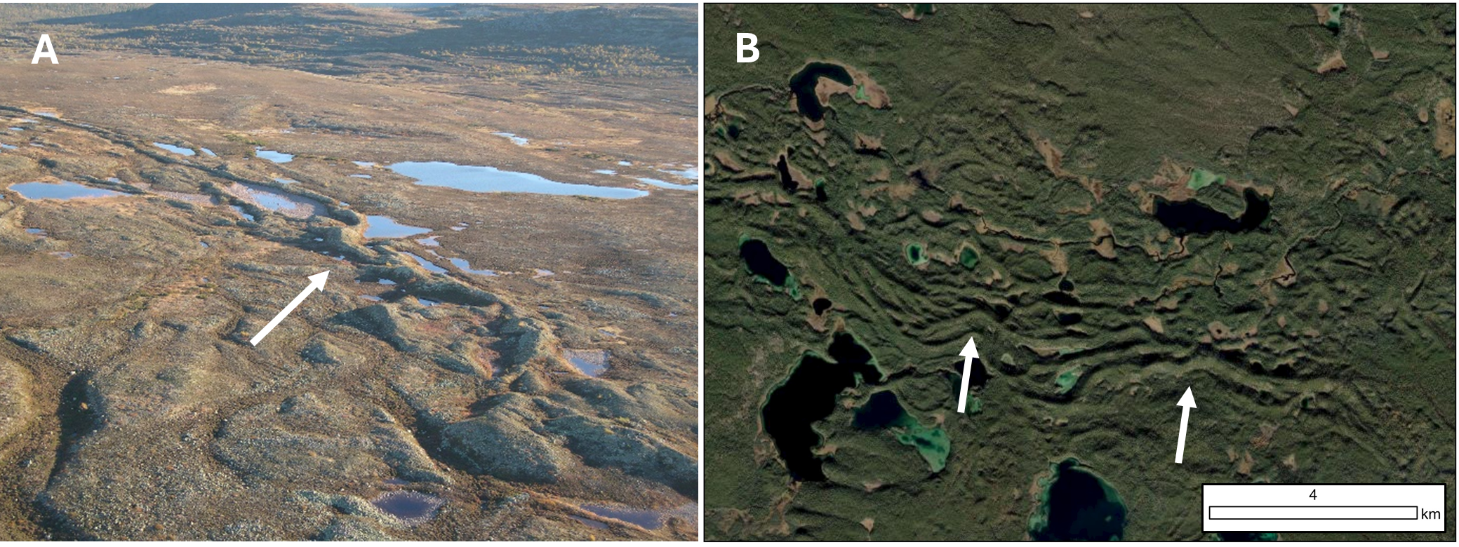
Eskers – long, sinuous ridges of sand and gravel – formed within subglacial meltwater tunnels and were deposited as ice retreated. Their presence traces the pathways of meltwater beneath the ice sheet12,13.
Figure 6. Eskers. (A) Esker ridge in Fulufjället National Park, Sweden. Credits: Hanna Lokrantz, 200414. Source: Wikimedia Commons. (B) Esker systems visible in satellite imagery, Canada. These landforms mark former subglacial meltwater drainage pathways. Credit: Google Earth, modified by Jakob Hamann, 2026.
Beyond the ice margin, meltwater deposited extensive outwash plains composed of sorted sand and gravel, and in some regions it became trapped between the retreating ice sheet and higher terrain, forming vast proglacial lakes such as Lake Agassiz15.
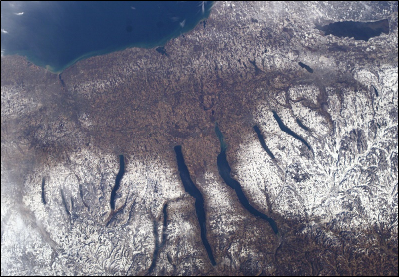
In areas like the Finger Lakes of New York, a set of elongate, roughly parallel basins, glacial erosion along pre-existing valleys combined with subsequent meltwater and lacustrine infilling to produce distinctive ellipsoidal lake systems that are characteristic of former ice-marginal and subglacial environments16.
Figure 7. The Finger Lakes of New York, USA. These elongated basins were formed through glacial erosion and meltwater modification during retreat of the Laurentide Ice Sheet. Credit: NASA, 200417ESRI Interactive map showing the reconstructed Laurentide Ice Sheet extent, The Great Lakes and Flowlines. Map created by Dr Bethan Davies.
Regional patterns and ice-sheet dynamics
Glacial landforms are not distributed evenly across North America. In central Canada and parts of the northern United States, extensive drumlin fields and MSGLs indicate zones of fast ice flow and dynamic ice streams9. In contrast, regions of the Canadian Shield preserve evidence of slower-moving or cold-based ice, where erosion was more limited and preglacial terrain was partly preserved18.
Large moraine systems mark major stillstands or re-advances of the ice margin, while extensive meltwater networks reflect substantial ice thinning and drainage reorganization during retreat of the Laurentide Ice Sheet.
Taken together, these regional patterns show that the Laurentide Ice Sheet was not a uniform body of ice but a dynamic and spatially variable system, with sectors that behaved differently depending on climate, topography, and basal conditions; the geomorphological record therefore provides critical insight into the internal structure and changing behaviour of this former continental-scale ice sheet.
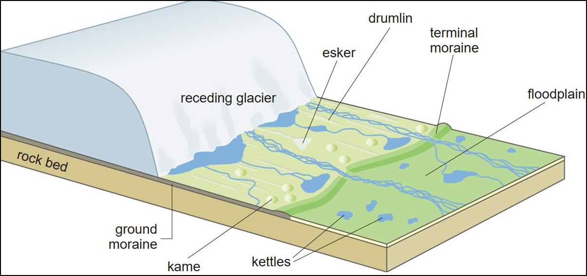
Figure 8. Schematic illustration showing a typical pro-glacial landscape after glacier retreat. Credit: Hans Hillewaert, 200519.
Benn, D. I., & Evans, D. J. A. (2014). Glaciers and glaciation. Routledge.
Kleman, J., & Borgström, I. (1996). Reconstruction of palaeo-ice sheets: the use of geomorphological data. Earth Surface Processes and Landforms, 21(10), 893-909.
Clark, C. D. (1993). Mega-scale glacial lineations and cross-cutting ice-flow landforms. Earth Surface Processes and Landforms, 18(1), 1-29.
Margold, M., Stokes, C. R., & Clark, C. D. (2015). Ice streams in the Laurentide Ice Sheet: Identification, characteristics and comparison to modern ice sheets. Earth-Science Reviews, 143, 117-146.
Dyke, A. S. (2004). An outline of North American deglaciation with emphasis on central and northern Canada. Developments in Quaternary Sciences, 2, 373-424.
Stokes, C. R., Tarasov, L., Blomdin, R., Cronin, T. M., Fisher, T. G., Gyllencreutz, R., … & Teller, J. T. (2015). On the reconstruction of palaeo-ice sheets: Recent advances and future challenges. Quaternary Science Reviews, 125, 15-49.
Livingstone, S. J., Storrar, R. D., Hillier, J. K., Stokes, C. R., Clark, C. D., & Tarasov, L. (2015). An ice-sheet scale comparison of eskers with modelled subglacial drainage routes. Geomorphology, 246, 104-112.
Núñez Ferreira, F. A., Zoet, L. K., Rawling III, J. E., Haseloff, M., Rehwald, M., & Ullman, D. J. (2025). Subglacial hydrology insights from eskers developed atop soft beds of the Laurentide ice sheet. Earth Surface Processes and Landforms, 50(1), e6037.
Süfke, F., Gutjahr, M., Keigwin, L. D., Reilly, B., Giosan, L., & Lippold, J. (2022). Arctic drainage of Laurentide Ice Sheet meltwater throughout the past 14,700 years. Communications Earth & Environment, 3(1), 98.
Mullins, H. T., & Hinchey, E. J. (1989). Erosion and infill of New York Finger Lakes: Implications for Laurentide ice sheet deglaciation. Geology, 17(7), 622-625.
Kleman, J., Borgström, I., & Stroeven, A. P. (2006). Reconstruction of palaeo-ice sheets and ice-sheet dynamics. Quaternary Science Reviews, 25(17-18), 2388-2413.