Periglacial Landforms

‘Periglacial’ describes a landscape that undergoes seasonal freezing and thawing, typically on the fringes of past and present glaciated regions.

Image of permafrost. Source: US Geological Survey

The landscapes are governed by specific depositional and erosional processes, and therefore produce completely unique landforms [1].

A dominant characteristic of periglacial landscapes is the presence of permafrost – ground that is frozen all year round for over two consecutive years. However, permafrost is rapidly shrinking in the Northern Hemisphere by 60,000-230,000 km2 per decade [2,3].

The uppermost section of permafrost is called the active layer. It undergoes annual freezing and thawing, and is partly responsible for the formation of many periglacial landforms. This is because several periglacial processes are initiated in the active layer, including nivation [4,5], mass movements (even on gentle slopes [6]), and frost heave [7,8].

Studying these landscapes is very important, as they represent huge areas of relatively unstable, unsafe ground that also have the potential to release substantial volumes of carbon [9,10]. They may even inform us of past and present (peri)glacial processes on other planets! [11,12]

Landforms

Blockfields

A combination of chemical and mechanical weathering can fracture bedrock below the active layer. Over time, these processes produce an uneven bouldery landscape known as a blockfield, which is revealed once ice or permafrost disappears.

Blockfields potentially began forming up to 23 million years ago during the Neogene, when chemical weathering initiated the slow process of eroding jointed bedrock [13].

Figure 1: Blockfields in Co. Mayo (a) and Co. Donegal (b), Ireland, from Wilson (2017) [15].

Ice Wedges

Ice wedges are vertically-oriented wedge-shaped growths of ice that occur near the surface of permafrost. They form where a temperature differential in the permafrost causes the ground to crack, allowing water to enter, refreeze, and expand.

Ice wedges only ever form in periglacial environments. This makes them valuable for identifying former periglacial landscapes [16] and studying past prevailing winter climatic conditions [17].

Figure 2: Ice wedges on Garry Island, Northwest Territories, Canada. The wedge on the left is about 2 m wide and 6 m deep. From MacKay (2000) [18].

Patterned Ground

Figure 3: Stone circles (a), labyrinths (b), stripes (c), and polygons (d) from the periglacial environments of Spitsbergen (Norway) and Alaska (USA). From Kessler and Werner (2003) [20].

The ‘ordered’ shapes produced by the organisation of sediment and stones are collectively known as ‘patterned ground’. These landforms include polygonal shapes, stone circles and stripes, and labyrinths.

Each pattern is produced during the repeated freezing and thawing of the active layer. Initial freezing separates and sorts solid from stones at/ near the ground surface, whilst subsequent thawing once again redistributes these materials into new orientations. This cycle can operate on decadal to centennial timescales to produce such landforms.

This process is influenced by the pre-existing internal structure of the sediments [19], as well as hillslope angle, which governs the formation of stone stripes and circles [20,21].

Pingos

The Innuit word ‘pingo’ here describes tall, typically circular mounds of former lake sediments in periglacial environments. Over 95% of all pingos are located in the continuous permafrost regions of Arctic North America and northern Asia, where they total >10,000 individuals [22].

Pingos form when growing permafrost uplifts unfrozen sediments (i.e. frost heave) beneath the surface of a draining lake, ultimately creating a stable, predominantly ice-cored mound where the lake was deepest [23].

This process can repeat itself over thousands of years to produce a landscape of multiple buried pingo complexes [24].

Figure 4: Two pingos, about 28 m (a) and 7 m (b) tall, found in drained thermokarst lakes (see below section) in Siberia. From Grosse and Jones (2011) [22].

Solifluction Lobes

Figure 5: Turf bank solifluction lobe (b and c) near the Turtmann glacier (a) in southern Switzerland. From Draebing and Eichel (2017) [26].

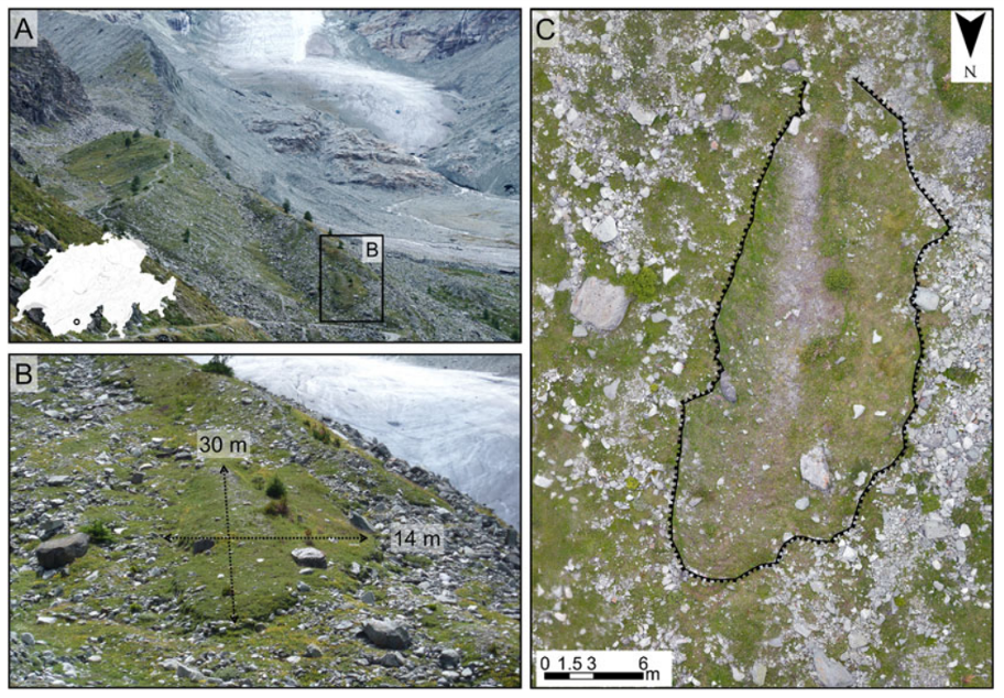
Soils can become highly saturated with moisture when permafrost prevents water percolating deep into the ground. This allows material to start flowing (solifluction) downhill in a lobate structure.

These solifluction lobes will flow until they reach a natural barrier (e.g. a knick point) or melting permafrost finally allows water to percolate away from the lobe [25]. Vegetation cover may also stabilise a lobe, ceasing its growth [26].

Terracettes

Wide, stepped hillslopes that have formed naturally in periglacial environments are known as terracettes.

It is generally agreed that terracettes form when soil creep processes and periglacial freeze-thaw cycles interact, creating regular step features on >20° slopes [27,28]. Some suggest that people and livestock amplify these features when they are used as walkways [29].
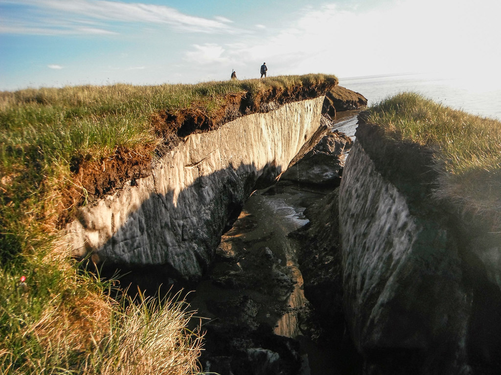
Thermokast

‘Thermokarst’ landforms are produced when permafrost and ice-rich ground masses thaw. A variety of landforms are characteristic of thermokarst landscapes, but some of the key features are described below.

Figure 6: Satellite imagery of thermokarst lakes in Siberia, present in a range of permafrost conditions (i.e. isolated/ sporadic to continuous). From Serikova et al. (2019) [10].

Thermokarst lakes can form as water ponds on the surface of thawing permafrost. They can grow remarkably quickly as a response to warming climate and environmental factors such as forest fires [30].

Similarly, thermokarst bogs form as water ponds on ice-rich peat. These bogs are poorly-drained by fluvial activity and groundwater, providing a unique habitat for stale-water plants [31].

Mass movement landforms are also common in thermokarst landscapes. Thaw slumps and active layer detachments slides are both usually triggered by enhanced thawing and mechanical erosion in the active layer, which is typical of thermokarst environments [6,31].

References


1. Queen, C.W. and Nelson, F.E. (2022) ‘Characteristic periglacial topography: Multi-scale hypsometric analysis of cryoplanated uplands in Beringia’, Permafrost and Periglacial Processes, 33, pp. 241-263.

2. Guo, D. and Wang, H. (2017) ‘Simulated historical (1901-2010) changes in the permafrost extent and active layer thickness in the Northern Hemisphere’, Journal of Geophysical Research: Atmospheres, 122, pp. 12285-12295.

3. Li, G., Zhang, M., Pei, W., Melnikov, A., Khristoforov, I., Li, R. and Yu, F. (2022) ‘Changes in permafrost extent and active layer thickness in the Northern Hemisphere from 1969 to 2018’, Science of The Total Environment, 804, 150182.

4. Christiansen, H.H. (1998) ‘Nivation forms and processes in unconsolidated sediments, NE Greenland’, Earth Surface Processes and Landforms, 23(8), pp. 751-760.

5. Thorn, C.E. and Hall, K. (2002) ‘Nivation and cryoplanation: the case for scrutiny and integration’, Progress in Physical Geography, 26(4), pp. 533-550.

6. Jiang, G., Gao, S., Lewkowicz, A.G., Zhao, H., Pang, S. and Wu, Q. (2022) ‘Development of a rapid active layer detachment slide in the Fenghuoshan Mountains, Qinghai-Tibet Plateau’, Permafrost and Periglacial Processes, 33, pp. 298-309.

7. Wilen, L.A. and Dash, J.G. (1995) ‘Frost heave dynamics at a single crystal interface’, Physical Review Letters, 74(25), pp. 5076-5079.

8. Rempel, A.W. (2010) ‘Frost heave’, Journal of Glaciology, 56(200), pp. 1122-1128.

9. Olefeldt, D., Goswami, S., Grosse, G., Hayes, D., Hugelius, G., Kuhry, P., McGuire, A.D., Romanovsky, V.E., Sannel, A.B.K., Schuur, E.A.G. and Turetsky, M.R. (2016) ‘Circumpolar distribution and carbon storage of thermokarst landscapes’, Nature Communications, 7, doi.org/10.1038/ncomms13043

10. Serikova, S., Pokrovsky, O.S., Laudon, H., Krickov, I.V., Lim, A.G., Manasypov, R.M. and Karlsson, J. (2019) ‘High carbon emissions from thermokarst lakes of Western Siberia’, Nature Communications, 10, https://doi.org/10.1038/s41467-019-09592-1

11. Burr, D.M., Tanaka, K.L. and Yoshikawa, K. (2009) ‘Pingos on Earth and Mars’, Planetary and Space Science, 57(5-6), pp. 541-555.

12. Johnson, A., Reiss, D., Hauber, E., Zanetti, M., Heisinger, H., Johansson, L. and Olvmo, M. (2012) ‘Periglacial mass-wasting landforms on Mars suggestive of transient liquid water in the recent past: Insights from solifluction lobes on Svalbard’, Icarus, 218(1), pp. 489-505.

13. Rea, B.R., Whalley, W.B., Rainey, M.M. and Gordon, J.E. (1996) ‘Blockfields, old or new? Evidence and implications from some plateaus in northern Norway’, Geomorphology, 15, pp. 190-121.

14. Ballantyne, C.K. (2010) ‘A general model of autochthonous blockfield evolution’, Permafrost and Periglacial Processes, 21, pp. 289-300.

15. Wilson, P. (2017) ‘Periglacial and paraglacial processes, landforms and sediments’, in Coxon, P, McCarron, S. and Mitchell, F. (eds.) Advances in Irish Quaternary Studies, 1st edn. Atlantic Press: Paris, pp. 151-180.

16. Harry, D.G. and Gozdzik, J.S. (1988) ‘Ice wedges: growth, thaw transformation, and palaeoenvironmental significance’, Journal of Quaternary Science, 3(1), pp. 39-55.

17. Opel, T., Meyer, H., Wetterich, S., Laepple, T., Dereviagin, A. and Murton, J. (2018) ‘Ice wedges as archives of winter paleoclimate: A review’, Permafrost and Periglacial Processes, 29, pp. 199-209.

18. MacKay, J.R. (2000) ‘Thermally induced movements in ice-wedge polygons, western Arctic coast: a long-term study’, Géographie Physique et Quaternaire, 54(1), pp. 41-68.

19. Forte, E., French, H.M., Raffi, R., Santin, I. and Guglielmin, M. (2022) ‘Investigations of polygonal patterned ground in continuous Antarctic permafrost by means of ground penetrating radar and electrical resistivity tomography: Some unexpected correlations’, Permafrost and Periglacial Processes, 33, pp. 226-240.

20. Kessler, M.A. and Werner, B.T. (2003) ‘Self-organization of sorted patterned ground’, Science, 299(5605), pp. 380-383.

21. Mann, D. (2003) ‘On patterned ground’, Science, 299(5605), pp. 354-355.

22. Grosse, G. and Jones, B.M. (2011) ‘Spatial distribution of pingos in northern Asia’, The Cryosphere, 5, pp. 13-33.

23. Gurney, S.D. (1998) ‘Aspects of the genesis and geomorphology of pingos: perennial permafrost mounds’, Progress in Physical Geography, 22(3), pp. 307-324.

24. Blyakharchuk, T.A., Wright, H.E., Borodavko, P.S., van der Knaap, W.O. and Ammann, B. (2008) ‘The role of pingos in the development of the Dzhangyskol lake-pingo complex, central Altai Mountains, southern Siberia’, Palaeogeography, Palaeoclimatology, Palaeoecology, 257(4), pp. 401-420.

25. Matsuoka, N., Ikeda, A. and Date, T. (2005) ‘Morphometric analysis of solifluction lobes and rock glaciers in the Swiss Alps’, Permafrost and Periglacial Processes, 16, pp. 99-113.

26. Draebing, D. and Eichel, J. (2017) ‘Spatial controls on turf-banked solifluction lobes and their role for paraglacial adjustment in glacier forelands’, Permafrost and Periglacial Processes, 28, pp. 446-459.

27. Auzet, A.-V. and Ambroise, B. (1996) ‘Soil creep dynamics, soil moisture and temperature conditions on a forested slope in the granitic Vosges Mountains, France’, Earth Surface Processes and Landforms, 21, pp. 531-542.

28. Weihs, B.J. and Shroder, J.F. (2011) ‘Mega-terracettes and related ungulate activities in Loess Hills, Iowa, USA’, Zeitschrift für Geomorphologie, 55(1), pp. 45-61.

29. Henck, A., Taylor, J., Lu, H., Li, Y., Yang, Q., Grub, B., Breslow, S.J., Robbins, A., Elliott, A., Hinckley, T., Combs, J., Urgenson, L., Widder, S., Hu, X., Ma, Z., Yuan, Y., Jian, D., Liao, X. and Tang, Y. (2010) ‘Anthropogenic hillslope terraces and swidden agriculture in Jiuzhaigou National Park, northern Sichuan, China’, Quaternary Research, 73, pp. 201-207.

30. Burn, C.R. and Smith, M.W. (1990) ‘Development of thermokarst lakes during the Holocene at sites near Mayo, Yukon Territory’, Permafrost and Periglacial Processes, 1, pp. 161-176.

31. Kokelj, S.V. and Jorgenson, M.T. (2013) ‘Advances in thermokarst research’, Permafrost and Periglacial Processes, 24, pp. 108-119.

About the Author

Hi I am Alex Clark, I am a PhD student currently working on a project that combines high-resolution geomorphological mapping with new chronological evidence to reconstruct palaeo-ice dynamics in NE Ireland during the Late Glacial (~18,000-15,000 years ago). I am primarily interested in past ice-climate interactions, digital mapping (GIS), and tephrochronology, but enjoy exploring other aspects of geography and the environmental sciences in my research.

About

Guest posts are invited articles written by experts in their field.

3 thoughts on “Periglacial Landforms”

Leave a Reply

Your email address will not be published. Required fields are marked *

This site uses Akismet to reduce spam. Learn how your comment data is processed.

This site uses cookies. Find out more about this site’s cookies.